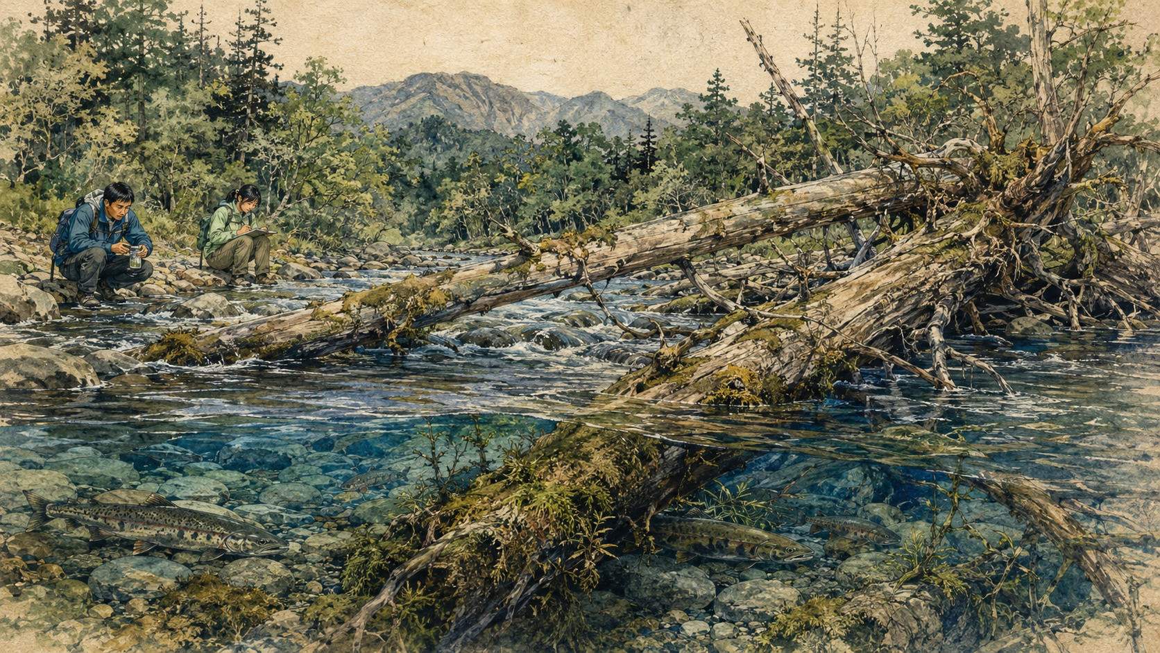
In spring, snow releases northern Hokkaido’s mountain rivers. Water does not remain inside the channel that looks like “the river” on a map. It overtops banks, finds abandoned threads, bends around root wads and fills long depressions beneath the forest. By late summer and fall, many of those paths no longer flow. Some dry. Others remain as narrow ponds and cloudy backwaters, still holding water after their visible connection to the mainstem disappears.
For generations, such places have been easy to mistake for leftovers. They may be too thin for a conventional map, motionless during a low-water field visit and inconvenient for drainage. Yet when scientists from Tohoku University, Hokkaido University, the University of Tokyo and Colorado State University measured the whole riverscape, the leftovers became centers. Habitats small in area supported animals that were scarce elsewhere.
The team surveyed the Butokamabetsu River where it runs through Hokkaido University’s Uryu Experimental Forest. Across 9.2 kilometers of main channel, researchers recorded 631 wood pieces wider than 15 centimeters, including 56 wider than 50 centimeters, and 77 accumulations known as logjams. They also mapped 19 permanently flowing side channels, 29 channels that carried mainstem water at high flow but became still at base flow, and 38 disconnected former channels that held ponded water.
Counting 631 pieces—and looking at two different rivers
The paper, published in Ecosphere on August 12, 2026, did more than sample fish beside convenient pools. It put geomorphology, hydrology and biological distributions onto the same map. Drones flew the corridor during November 2021 base flow and again during the May 2022 snowmelt recession. Overlapping images became an orthomosaic; field observations checked what the aerial view could not resolve. The comparison revealed where water passed through, where it stopped and where it vanished.
At snowmelt stage, 90% of the side-channel network carried through-flowing river water. The other 10% was disconnected and stagnant. At base flow, only 20% still carried mainstem flow; 46% retained standing water and 34% had dried. The same landform could therefore be a stream, a pond and a dry swale at different moments of the year.
| Study category | Count | Hydrology | Ecological role |
|---|---|---|---|
| Permanent-flow side channel | 19 | Surface connection at snowmelt and base flow | Favors larger fish and organisms adapted to running water |
| Transient-flow channel | 29 | Through-flow at high water; standing water at low water | Combines periodic exchange with a low-velocity refuge |
| Disconnected former channel | 38 | No surface connection to the mainstem; water persists as a pond | Important to plankton, amphibians and juvenile taimen, but vulnerable to low oxygen |
The main channel averaged 12.3 meters wide, but the valley floor averaged 243.8 meters. Depending on location, one to eight channel threads crossed that broad floor. A model containing the number of wood pieces, number of logjams and channel slope best explained channel count. Wood and jams each had a statistically significant positive association. The model’s adjusted R-squared, however, was 0.23. Much of the river’s form remained attributable to things the model did not capture—sediment, flood history, valley shape, vegetation and other processes.
Wood does more than provide cover
Ecologists have long understood direct benefits from streamside forest. Shade moderates temperature. Terrestrial insects fall from branches. Submerged roots and trunks provide cover from predators, while the slack water behind a log can offer a place to rest. The new paper foregrounds an indirect effect at a larger scale: wood can help build the landforms that create whole habitats.
When wood accumulates across a channel, a persistent jam can back water upstream. During a flood, that raised surface can spill into a lower route across the valley and initiate an avulsion—a new branch of the river. Years later, the jam may fail or decay. Sediment may fill the branch entrance. A permanently flowing side channel can become intermittent and eventually ponded. Because wood moves, locks together and breaks apart, it can help create different degrees of connection side by side.
A natural river’s diversity does not come only from preserving the same pool forever. It also comes from room to flow, stop, dry and reconnect.
Rock and concrete can redirect water, too. Wood differs because it is temporary. It travels, snags, forms jams, decays and collapses. The authors propose that this cycle may be central to maintaining varied connectivity. They did not, however, follow every jam from formation through failure and channel abandonment. Their deliberately careful conclusion is that large wood potentially plays an important role.
Small in area is not small in importance
The researchers combined density measurements for aquatic animals with the mapped area of each habitat type. That allowed them to estimate which parts of the 9.2-kilometer riverscape supported each population, rather than merely reporting where an animal happened to be caught. Four of 11 fish taxa, five of 26 benthic macroinvertebrate taxa, all three plankton taxa and both amphibian taxa primarily used transient or disconnected channels.
Transient channels occupied an area equal to only 9% of the main channel; disconnected former channels, 6%. Yet for organisms adapted to quiet water, those small percentages contained much of the available habitat. Many still-water taxa were more prominent in transient channels than in fully disconnected ponds. The team points to one likely reason: without exchange, organic matter can accumulate and dissolved oxygen can fall. Connection is not simply good or bad. A spectrum of connections supplies different conditions.
| Group | Taxa examined | Primarily transient or disconnected | Meaning |
|---|---|---|---|
| Fish | 11 | 4 | Includes species that switch primary habitat as they grow |
| Benthic macroinvertebrates | 26 | 5 | Some depend on low-flow, organic-rich floodplain water |
| Plankton | 3 | 3 | Populations concentrate where current does not constantly carry them away |
| Amphibians | 2 | 2 | Quiet breeding and larval habitat can be indispensable |
A char cannot complete its life in one current
The clearest life-stage pattern came from the white-spotted char, Salvelinus leucomaenis. Researchers captured 147, more than any other fish. After dividing them into age cohorts by body mass, the team estimated that 87% of age-zero fish lived in transient channels and another 5% in disconnected channels. Among age-one fish, the shares were 42% and 14%. The pattern reversed among larger animals: 89% of age-two and 98% of age-three-or-older char occurred in permanent flow.
A small fish can benefit from weak current, lower energy costs and refuge from large predators. As it grows, cold oxygenated flow and deeper habitat become increasingly important. Conservation therefore cannot choose between “the nursery pond” and “the adult river.” It must retain a route between them.
The estimates deserve caution. Electrofishers capture the smallest fish inefficiently, so the authors say age-zero abundance was probably underestimated. Fish may also have moved into or out of the 9.2-kilometer study segment. Even so, habitat use differed so sharply among cohorts that calling the char merely a “main-channel fish” hides the geography of its childhood.
The endangered giant begins in slow, turbid water
The stakes are even higher for Sakhalin taimen, Parahucho perryi, one of Japan’s largest freshwater fishes. It is listed as Critically Endangered by the IUCN and Endangered on Japan’s national Red List. The National Institute for Environmental Studies says historical records place it from Hokkaido into Tohoku; in Japan today it persists in only roughly a dozen rivers in northern and eastern Hokkaido.
In the riverscape estimate, taimen collected for the biological survey primarily occupied quiet floodplain water in transient or disconnected channels. That does not make Sakhalin taimen a pond species. A 2023 study in the same river makes the life-stage split visible. At 30 side-channel sites, every captured taimen was a juvenile, 69 to 137 millimeters long. Juvenile density tended to be higher in very slow, turbid, still-water conditions. At 21 main-channel sites, every observed taimen was a subadult or adult, 300 to 800 millimeters long, and larger fish favored deep pools with abundant cover, including woody debris.
The young and the adults inhabit different landscapes. Mature taimen may move among coastal water, estuaries, lower rivers, main channels and spawning tributaries, and unlike Pacific salmon they can survive spawning and return in later years. A 2020 environmental-DNA survey detected taimen in seven of 120 Hokkaido rivers and suggested biomass was heavily concentrated in a few regions. In the Sarufutsu system, National Institute for Environmental Studies tracking found some tagged fish returning as much as 24 kilometers and homing to the same small tributary at rates near 90%.
The quiet floodplain channel may therefore represent an overlooked bottleneck in the childhood of a giant fish. A deep adult pool, a slow juvenile backwater, a functioning estuary and an accessible spawning stream are not substitutes. Break the network in one place and the life cycle eventually meets a wall.
A forest founded in 1901 preserved a baseline
This study was possible because the Butokamabetsu is not an ordinary modern river. Hokkaido University’s Uryu Experimental Forest was established in 1901 and covers about 25,000 hectares in the Uryu basin around Lake Shumarinai. Winter temperatures can reach minus 35 degrees Celsius and snow depth exceeds two meters. The northern forest contains mixed conifer–broadleaf stands, pure oak, wetland Sakhalin spruce and extensive riparian forest.
Parts were logged decades ago, the paper notes, but wood more than a meter in diameter remains in the river corridor. Snow generally persists from late November into early May and can approach three meters deep. The April–May melt produces a river that is physically different from its summer and autumn form. This is not a wholly untouched “primeval” watershed. It is, however, a rare reference for a multithread mountain floodplain now largely missing from Japan.
A reference site is not a museum display. It reveals what a restoration target could include. The familiar image of a natural mountain stream as one clean, narrow thread may itself reflect generations spent looking at altered channels. When the authors call the Butokamabetsu a “lost and forgotten baseline,” they are describing a loss of memory as well as habitat.
1901 Hokkaido University establishes the Uryu Experimental Forest.
20th century Logging, channelization and floodplain conversion reduce multithread rivers and in-channel wood across Japan.
From the 1970s North American research increasingly documents the role of wood in forming pools, storing sediment and supporting salmonids.
2008 A Japanese review, “Effectiveness of large woody debris to create salmonid habitat,” consolidates field evidence and wood-addition experiments.
November 2021 Drone imagery records the Butokamabetsu at base flow.
May 2022 Snowmelt-stage imagery is integrated with field and biological surveys.
August 12, 2026 The 9.2-kilometer synthesis appears in Ecosphere.
How one clean channel became the ideal
There were practical reasons to treat wood as an obstruction. Floating trunks impeded navigation, clogged intakes, collected on bridge piers and raised floodwater. Straightening a river, removing snags and draining a floodplain could move water faster, protect homes and make land usable for agriculture.
The Hokkaido Regional Development Bureau’s history of the Kushiro River captures both benefits and costs. After a major 1920 flood, channel relocation and straightening advanced. Completion of the New Kushiro River in 1931 helped free the city from recurring inundation. Shortcuts and levees continued upstream into the 1980s, reducing floods and enabling dairy farming and urban expansion. Later, faster flow, sediment delivery and wetland change became problems in their own right; by the 2000s, remeandering and nature restoration had entered public policy.
The new paper gives the broader Japanese pattern in one sentence: on many wide valley floors, trees were logged, streams channelized and floodplains converted to rice fields over decades or centuries. This is not a claim that older engineers were ignorant. Their works responded to lethal floods, food production and livelihoods. It means science can now account for long-term ecological costs that were once poorly measured.
Where wood should stay—and where it should not
“Wood benefits habitat” and “floating wood can be dangerous” are both true. Japan’s transport ministry is actively developing better flood-risk methods for mountain streams where sediment and wood can block bridges, reduce channel capacity and produce inundation beyond conventional hazard estimates. The broad, unsettled valley of the Butokamabetsu cannot be managed like a residential river passing through a narrow bridge opening.
The useful policy space lies between removing everything and abandoning everything.
- Low-risk natural corridors: protect riparian forests, future wood recruitment and enough valley width for lateral movement.
- Restorable reaches: reconnect former channels or lower floodplain surfaces; where appropriate, use engineered and anchored large wood, then monitor high and low water.
- Upstream of bridges, culverts and intakes: inspect accumulation points, forecast blockage and remove or capture mobile wood selectively.
- Urban or confined reaches: prioritize flood safety while restoring complexity in safer tributaries, setbacks or upstream corridors.
- Biological monitoring: count juveniles as well as adults, and amphibians, plankton and invertebrates as well as fish, at more than one water level.
- Adaptive management: measure landform, temperature, oxygen, floods and wood movement before and after intervention, and revise the design.
Climate change makes the choice harder. More extreme rainfall can mobilize wood and raise blockage risk, while drought and warmer water can reduce refuge for cold-water fish. Riparian shade and habitats with different connectivity may provide resilience, but this study did not test climate adaptation directly. A plausible benefit is not a measured outcome.
What the study established—and what it did not
| Supported by the study | Not yet established |
|---|---|
| Reaches with more wood and logjams had statistically more channel threads. | Adding wood will create the same channel response in every river. |
| Taxa from fish, invertebrates, plankton and amphibians primarily used transient or disconnected waters. | A causal biodiversity gain attributable to wood alone. |
| Young and older white-spotted char used sharply different primary habitats. | Direct, tagged tracking of each fish across its full life. |
| The Butokamabetsu is a valuable reference for a near-natural multithread floodplain. | A universal template transferable unchanged to urban or steep confined rivers. |
Upscaling density measurements to the full habitat area compounds sampling and statistical uncertainty. Deep main-channel habitat could not be effectively electrofished, which is why adult taimen were absent from that survey. Movement outside the study segment was not fully observed. Comparisons with wood abundance elsewhere are difficult because diameter cutoffs and methods differ. The paper’s achievement is not a final causal formula. It is bringing landform, water and life into one riverscape analysis.
The next step is long-term observation of jams forming and failing, channel entrances opening and filling, and floods rearranging the mosaic. Replication is needed in rivers with different geology, climate and management history. Where managers test wood additions or side-channel reconnection safely, projects should include controls and measure both ecological benefit and flood hazard.
The Butokamabetsu offers less a new river component than a new way of seeing. A map that colors only the main channel blue erases fish childhoods, amphibian breeding water and the routes opened by flood and snowmelt. A pond can still be part of a river. A fallen tree is not always debris. Even a dry former channel belongs to river time if spring water will return.
Some species cannot complete a life in one clean channel. They require running water and still water, deep pools and shallow branches, forest and river, ordinary flow and flood, all functioning as one mobile system. The lesson of the 631 pieces is not why a natural river looks untidy. It is how that complexity gives life more places to begin.
Study at a glance
| Paper | Large wood supports hydrologically variable floodplain environments and aquatic biodiversity |
|---|---|
| Publication | Ecosphere 17(8): e70700, August 12, 2026. doi:10.1002/ecs2.70700 |
| Authors | Hiromi Uno, Junjiro Negishi, Kentaro Morita, Osamu Kishida and Ellen Wohl |
| Location | Butokamabetsu River, Hokkaido University Uryu Experimental Forest; 9.2 km of main channel |
| Methods | Base-flow drone survey in November 2021, snowmelt survey in May 2022, ground mapping of wood and channels, integrated with aquatic-animal density data |
| Main physical result | 631 wood pieces, 77 logjams, 19 permanent side channels, 29 transient channels and 38 disconnected former channels; positive association between wood/jams and channel count |
| Biological result | Four of 11 fish taxa, five of 26 benthic taxa, all three plankton taxa and both amphibian taxa primarily used transient or disconnected channels; char shifted habitat with age |
| Main limits | Single-river observational study; correlation rather than experimental causality; uncertainty in area-weighted population estimates; limited coverage of deep main-channel habitat and outside movement |
- Hokkaido University and Tohoku University joint research release (PDF, Japanese)
- Uno H. et al., “Large wood supports hydrologically variable floodplain environments and aquatic biodiversity,” Ecosphere
- Dryad dataset: Large wood supports hydrologically variable floodplain environments and aquatic biodiversity
- Endo H. et al., “Habitat characteristics of the Sakhalin taimen in the Butokamabetsu River,” Japanese Journal of Conservation Ecology
- Hokkaido University Field Science Center: Uryu Experimental Forest
- Mizumoto H. et al., “An Environmental DNA Survey on Distribution of an Endangered Salmonid Species, Parahucho perryi, in Hokkaido”
- National Institute for Environmental Studies: Sakhalin taimen migration and river connectivity (Japanese)
- Nagayama S. et al., “Effectiveness of large woody debris to create salmonid habitat”
- KAKEN research project: Formation of floodplain shifting mosaic in aquatic ecosystem
- Hokkaido Regional Development Bureau: History and restoration of the Kushiro River (Japanese)
- Ministry of Land, Infrastructure, Transport and Tourism: technical committee on sediment, wood and small-river flood risk (PDF, Japanese)
Editor’s note: “Fallen trees” is used as an accessible description; the study’s “large wood” includes individual pieces and logjams wider than 15 centimeters. The char is identified as Salvelinus leucomaenis from the paper and deposited dataset. We treat associations as correlations, not causal proof, and state limitations involving upscaling, capture efficiency and the single-river design. Sakhalin taimen conservation status follows the paper, IUCN-referencing research and Japan’s national Red List. Exchange-rate display supplied by the newsroom.