One earthquake, two numbers
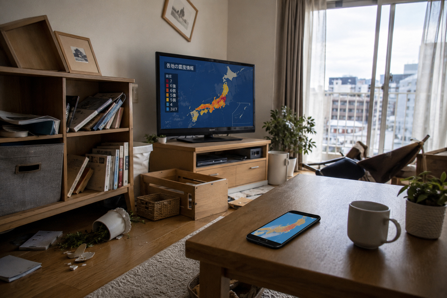
At about 7:30 a.m. on June 25, 2026, a magnitude 6.9 earthquake struck off Iwate Prefecture in northern Japan. The reported depth was about 50 kilometers. The strongest reported shaking was Shindo 6 Upper in Hashikami, Aomori Prefecture, with strong shaking also felt across parts of Iwate, Miyagi, and the wider Tohoku region. Officials said slight sea-level changes were possible along the coast, but damaging tsunami impacts were not expected.
Most readers outside Japan look first at one number: magnitude. That is the number used in international headlines. It lets a reader compare an earthquake in Japan with one in Chile, Turkey, Indonesia, California, or New Zealand. But in Japan, the number people watch just as closely is shindo, the Japan Meteorological Agency’s seismic intensity scale.
Both numbers matter. They do different jobs. Magnitude describes the size of the earthquake itself — the energy released by fault movement underground. Shindo describes the strength of shaking at a specific location — what people, buildings, roads, shelves, elevators, and ground actually experienced there. Magnitude is about the earthquake. Shindo is about the place.
Magnitude measures the earthquake itself
Magnitude is a measure of the size of the earthquake source. It is calculated from seismic records and, for modern large earthquakes, from estimates of the physical movement of the fault. It is useful because it gives scientists, governments, and the public a common way to compare earthquakes around the world.
But magnitude does not directly tell you what happened in a particular town. A large earthquake far offshore may produce only moderate shaking in a city. A smaller but shallow earthquake directly beneath a town can produce violent shaking. A deep earthquake may be felt across a wide area but with lower surface intensity. A shallow earthquake may be more localized but much more damaging near its source.
The U.S. Geological Survey explains the basic distinction clearly: magnitude is based on seismic records and describes the size of the earthquake, while intensity describes the effects of shaking at particular places. Japan’s shindo system follows that same practical logic, but with an important difference: Japan’s reported seismic intensity is now based on instruments placed across the country, not simply on subjective descriptions.
Shindo measures shaking where people live
Shindo is Japan’s local language for shaking. It tells people how strongly the ground moved at an observation point. The same earthquake can produce different shindo values in Tokyo, Morioka, Sendai, Hachinohe, or a small coastal town. Distance from the epicenter matters. Depth matters. The direction of rupture matters. So do local soils, topography, and the structure in which a person is standing.
The Japan Meteorological Agency notes that seismic intensity is observed at the site where a seismic intensity meter is installed and may vary even within the same city. It also notes that shaking can vary by floor and location inside a building; upper floors may experience amplified motion. That is why the number on the news is a guide, not a perfect measurement of every apartment, office, school, or hospital in the area.
Even with that caution, shindo is one of the most useful public-safety numbers in Japan. After an earthquake, people do not only want to know how much energy was released underground. They want to know whether shelves fell, whether elevators stopped, whether unreinforced walls might collapse, whether trains will be inspected, whether schools need to dismiss students, whether coastlines need tsunami action, and whether neighbors should be checked. Shindo is the number closest to those questions.
What Shindo 6 Upper means
Shindo 6 Upper is severe shaking. It is not a casual tremor. JMA’s explanatory tables describe Shindo 6 Upper as shaking strong enough that many people cannot remain standing and may only be able to move by crawling. Unsecured heavy furniture is likely to move or overturn. Doors may come off their tracks or be thrown open. Wall tiles and window glass may break and fall. Unreinforced concrete-block walls are especially dangerous.
That does not mean every building in a Shindo 6 Upper area collapses. Japan has repeatedly updated its seismic building standards, and modern reinforced structures can perform very differently from old wooden homes, unbraced walls, or buildings on poor ground. A well-built house with anchored furniture may suffer far less damage than a fragile structure nearby. But Shindo 6 Upper should always trigger serious safety checks.
For a household, Shindo 6 Upper means shoes by the bed matter. Furniture anchors matter. Flashlights matter. Gas checks matter. A plan for contacting family matters. It also means avoiding dangerous places after the first shaking stops: damaged walls, glass, roof tiles, slopes, riverbanks, seawalls, and old block walls. The danger often shifts from shaking to the aftermath.
| Number | What it means | How readers should use it |
|---|---|---|
| Magnitude | The size of the earthquake itself and the energy released at the source. | Use it to understand the overall event and compare earthquakes globally. |
| Shindo | The strength of shaking at a specific place. | Use it for local safety decisions, damage checks, and likely social disruption. |
| Depth | How far below the surface the earthquake occurred. | Use it with location and magnitude; shallow and deep quakes can feel very different. |
| Tsunami information | Whether sea-level changes or tsunami waves may occur. | Coastal residents must check tsunami alerts separately from shindo. |
Why Japan relies so heavily on shindo
Japan relies on shindo because earthquakes are not abstract here. They happen in stations, schools, ports, apartment towers, hospitals, factories, mountain villages, coastal towns, and crowded shopping streets. Japan sits near complex boundaries of major tectonic plates, producing subduction-zone earthquakes, inland crustal earthquakes, volcanic earthquakes, and long sequences of aftershocks.
That geography has made Japan a country where earthquake information must be operational. A headline number is not enough. Government agencies, municipalities, railways, utilities, hospitals, schools, and households all need to know where the strongest shaking occurred. They need to know which bridges, tracks, elevators, water lines, slopes, seawalls, and buildings should be inspected first.
Shindo is the first map of urgency. A maximum intensity report of Shindo 6 Upper immediately tells emergency managers that the affected locality may need damage checks, transport inspections, utility monitoring, school safety decisions, and public communication. The number is not just science. It is a trigger for action.
From human observation to instrument measurement
Historically, seismic intensity was based heavily on human observation. People described how the earthquake felt, what moved, what fell, and what was damaged. That tradition made sense before dense instrument networks existed. Many countries still use intensity scales that include observed damage and human reports.
But subjective observation has limits. Different observers can judge the same shaking differently. Reports take time to collect. Observation points may be sparse. Most importantly, strong shaking in the range of intensity 5 and 6 can produce very different damage patterns within the same broad category.
Japan’s modern shindo system changed significantly after lessons from major disasters, including the 1995 Great Hanshin-Awaji Earthquake. In 1996, Japan moved fully toward instrument-based seismic intensity reporting. The scale was refined into ten levels: 0, 1, 2, 3, 4, 5 Lower, 5 Upper, 6 Lower, 6 Upper, and 7. Splitting 5 and 6 into lower and upper categories gave officials and the public more useful detail in the range where decisions become urgent.
Why 5 and 6 are split into Lower and Upper
The difference between 5 Lower, 5 Upper, 6 Lower, and 6 Upper is not cosmetic. It matters for safety, inspections, and public messaging. At Shindo 5 Lower, many people are frightened and objects can fall. At 5 Upper, movement becomes difficult for many people, and unsecured furniture may overturn. At 6 Lower, standing becomes difficult, heavy furniture moves or falls, and doors may jam. At 6 Upper, standing is generally impossible for many people, and serious building and infrastructure concerns become more likely.
That detail helps prioritize response. A municipality reporting 6 Upper may need urgent checks of older homes, schools, hospitals, roads, bridges, slopes, water systems, and block walls. A railway may stop trains for inspection. Elevators with earthquake-control devices may stop automatically around strong-shaking thresholds. Utility companies may check gas, electric, and communication networks.
If Japan reported only “6,” too much useful information would be lost. A 6 Lower community and a 6 Upper community may both be in trouble, but the likely severity and the urgency of inspections can differ. The split creates a clearer public-safety language.
Soil and buildings can change the story
One reason shindo matters so much is that local ground conditions can amplify shaking. Soft soils, reclaimed land, river valleys, basins, and sediment-filled plains can behave differently from hard rock. The same seismic waves can arrive at two nearby locations and produce very different shaking.
Japan’s cities are full of this complexity. Many developed areas are on coastal plains, river mouths, reclaimed land, and valleys because those places are convenient for ports, farms, transport, and settlement. But convenience and seismic strength are not the same thing. A neighborhood’s history as a former river channel, marsh, fill area, or hillside development can matter when the ground begins to move.
Buildings also shape experience. A person on the ground floor of a small house may feel a different motion from someone on the 25th floor of a tower. Long-period ground motion can make tall buildings sway in a way that is frightening and operationally important even when local damage on the ground is limited. Shindo is a local measurement, but the lived experience can still vary inside the measurement area.
Reading the June 25 Iwate offshore earthquake
The June 25 earthquake is a good example of why readers should use both numbers. The magnitude was reported as 6.9, and the depth about 50 kilometers. That describes the event. The maximum reported shindo was 6 Upper in Hashikami, Aomori Prefecture. That describes the strongest observed shaking. The epicenter was off Iwate, but the strongest reported intensity was in Aomori. That is not a contradiction. Earthquake shaking does not follow prefectural borders or headline labels.
Fault geometry, depth, wave propagation, and local ground conditions all shape the intensity map. A place closer to the epicenter is not always the place with the highest reported intensity. A coastal earthquake can produce strong inland shaking. A town across a prefectural line can receive stronger motion than the place named in the epicenter description.
Readers should therefore avoid a common mistake: treating the epicenter name as the damage map. The phrase “off Iwate” tells us where the earthquake started. It does not tell us where shaking was strongest, where trains stopped, where schools checked students, where old walls may have cracked, or where residents most need information. For that, shindo is essential.
Shindo and tsunami are separate questions
Coastal Japan has another rule: strong shaking and tsunami danger must be checked separately. Shindo tells us how strongly the ground shook. Tsunami information tells us whether sea-level changes may follow. The two are related, but they are not the same.
A strong offshore earthquake may or may not generate a damaging tsunami. Tsunami risk depends on the earthquake’s mechanism, depth, location, seafloor displacement, and ocean conditions. The June 25 event reportedly carried the possibility of slight sea-level changes but no damaging tsunami concern. That is reassuring, but it is not a general rule for future earthquakes.
For anyone on the coast, the safest habit is simple: if the shaking is strong or long, move away from the water and check official tsunami information. Do not go to the harbor to look. Do not drive into a coastal low area to retrieve belongings. Do not wait for social-media confirmation. In Japan, tsunami information from official sources is part of earthquake literacy.
What households should do after strong shindo
Shindo should become a household action signal. After shaking of 5 Lower or greater, check for injuries, fire, gas smell, broken glass, falling objects, jammed doors, and unstable furniture. Put on shoes. Keep a flashlight nearby. Open a safe exit if possible. Avoid elevators. Stay away from walls, slopes, riverbanks, and damaged buildings.
After Shindo 6 Lower or 6 Upper, think about the second quake before it happens. Aftershocks can knock down what the first quake weakened. Move dangerous objects from high shelves. Keep water, medicine, cash, ID, phone batteries, and a radio ready. Check on elderly neighbors and people living alone. Follow municipality, JMA, NHK, police, and fire-department information before trusting viral posts.
The best response is not panic. It is inspection, communication, and preparation. Japan’s earthquake systems are built around speed, but households are still the first responders in the first few minutes. Knowing what shindo means makes those minutes better.
A guide for visitors and overseas readers
For visitors to Japan, shindo can be confusing because it is not the headline metric in many other countries. A traveler may understand “magnitude 6.9” but not “Shindo 6 Upper.” In Japan, the second number may be the more useful one for immediate safety.
If you are in Japan and an earthquake alert appears, look for your location’s seismic intensity, not only the maximum intensity nationwide. A maximum of Shindo 6 Upper somewhere in Tohoku does not mean Tokyo experienced that level of shaking. Conversely, a moderate national headline may still matter greatly if your town is close to the strongest shaking area.
The three questions to ask are: What was the magnitude? What was the shindo where I am? Is there tsunami information for my coast? Add one more if you are in a building: What floor am I on, and what objects around me can fall?
Shindo is not a fear number. It is a readiness number.
Shindo 6 Upper is a serious phrase, especially in northeastern Japan, where the memory of 2011 remains part of daily life. But seismic intensity is not meant to create fear. It is meant to turn shaking into action.
Japan’s shindo system is the product of long experience, hard lessons, dense observation networks, and a practical culture of disaster response. It connects science to trains, schools, elevators, hospitals, roads, water systems, and kitchens. It tells a country not only that an earthquake happened, but where people may need to act first.
That is why the June 25 offshore Iwate earthquake should be read through both numbers. M6.9 tells us the earthquake was large. Shindo 6 Upper tells us at least one community experienced severe shaking. The tsunami note tells coastal residents what to watch next. Together, those numbers are not just a report. They are a survival language.
- Magnitude describes the size of the earthquake itself.
- Shindo describes how strongly a specific place actually shook.
- Japan’s shindo scale has ten levels: 0, 1, 2, 3, 4, 5 Lower, 5 Upper, 6 Lower, 6 Upper, and 7.
- Shindo 6 Upper is severe shaking: many people cannot remain standing, furniture may overturn, and building safety checks become urgent.
- Always read earthquake news as a set: magnitude, maximum shindo, your local shindo, depth, and tsunami information.
Sources and references
This article uses public information from the Japan Meteorological Agency, the U.S. Geological Survey, Weathernews, and the Associated Press to explain the difference between magnitude and shindo, what Shindo 6 Upper means, and the reported facts of the June 25, 2026 offshore Iwate earthquake.
- JMA: Tables explaining the JMA Seismic Intensity Scale
- JMA: Monitoring of Earthquakes, Tsunamis and Volcanic Activity
- JMA: About seismic intensity
- JMA: Calculation of instrumental seismic intensity
- USGS: Difference between earthquake magnitude and intensity
- USGS: Magnitude, energy release, and shaking intensity
- Weathernews: M6.9 earthquake off Iwate, Shindo 6 Upper in Hashikami
- AP: Powerful 6.9-magnitude earthquake strikes off northern Japan