On Friday night, as Japan was already watching rain clouds and tropical storms, another warning came from the mountains. At around 10:29 p.m. on June 26, 2026, a magnitude 5.6 earthquake centered in Yamanashi shook a broad area that included Yamanashi, Kanagawa and the Tokyo metropolitan region. Reports said some structures were damaged and at least one landslide was triggered. There was no tsunami threat from this inland event. But the real worry was not only what the quake had already done. It was what the shaken ground might do next, with the rainy season front still active and two tropical systems approaching Japan.
The second danger after the shaking stops
A magnitude 5.6 earthquake may sound moderate beside the giant disasters that shape modern Japanese memory. But disaster risk is never determined by magnitude alone. It depends on where the ground moved, how shallow the quake was, what the local geology is like, how wet the ground had become, and what sits above or below a slope. The Yamanashi–Kanagawa quake mattered because it struck a part of Japan where mountains, roads, homes, tourism and rain are tightly connected.
The Japan Meteorological Agency’s seismic intensity scale measures the strength of shaking at a specific location, not the total energy of the earthquake. The same quake can feel different in a basin, on a ridge, on reclaimed land or on hard rock. Yamanashi’s basins and mountain walls, and western Kanagawa’s mix of urban corridors and steep terrain, make that distinction practical rather than academic. A short burst of shaking can leave a slope unstable long after the household furniture has stopped moving.
Yamanashi: beautiful mountain country, vulnerable slope country
Yamanashi is often described through the language of scenery: Mount Fuji, the Fuji Five Lakes, the Kofu Basin, vineyards, hot springs, campgrounds and roads that seem to run straight into rural Japan. Disaster-prevention language describes the same place differently. It is a landlocked prefecture ringed by mountains, where communities, roads and utilities often run through valleys and along steep terrain. The mountain is not only a view. It is a structure that catches rain, stores water, fractures, drains and sometimes fails.
Yamanashi Prefecture’s own disaster-prevention material treats earthquake damage as a multi-layered problem. Active faults, subduction-zone earthquakes affecting the broader Tokyo region, isolated settlements, road access, bridges and mountain infrastructure all matter. The practical question is not only whether a house collapses. It is whether the road to that house remains open, whether a retaining wall has shifted, whether an ambulance can reach a valley community, and whether a small landslide blocks the only route out.
Western Kanagawa: where the city edge meets the mountains
Kanagawa is often imagined as Yokohama, Kawasaki and the Shonan coast. But its western side is another geography: Hakone, Tanzawa, Odawara, resort roads, hot-spring towns, rail lines and mountain highways. Shaking there does not need to create a metropolitan catastrophe to become dangerous. A cracked road shoulder, a loosened retaining wall, a fallen rock or a blocked local road can turn a normal weekend trip into an emergency.
That is why the pairing of Yamanashi and Kanagawa in this quake matters. This was not just one prefecture’s event. It affected a living corridor west of Tokyo, where tourists, commuters, freight, school routes and emergency services cross prefectural borders. People travel to Fuji, Hakone and mountain resorts without thinking much about administrative lines. Disaster response has to think in lines: roads, railways, tunnels, bridges, slopes, hospitals, shelters and return routes.
When rain and earthquakes overlap
The timing made the story more serious. Japan was already under heavy rain from a seasonal front, while tropical systems Mekkhala and Higos were threatening parts of the country. Southern and western Japan had been dealing with evacuation advisories, flight cancellations, train disruptions and road problems. Then the inland quake arrived.
This is what disaster planners call a compound risk. An earthquake loosens ground. Rain adds weight and pressure. Road inspections slow movement. Evacuation routes can become less reliable. Tourists may not know the local hazard map. Older residents may hesitate to leave. If power or communication problems join the mix, the difficulty of seeing the whole situation rises quickly. In this kind of weekend, the question is not only “how strong was the earthquake?” It is “how much more rain will the shaken slopes receive?”
The 1923 lesson: Kanto disasters have always been compound disasters
For the Kanto region and its western edge, earthquake history inevitably reaches back to the Great Kanto Earthquake of 1923. That disaster was far larger than the Yamanashi event, and no comparison in scale is intended. But its lesson is still relevant: the name of a disaster can be singular while the causes of death and damage are plural. In 1923, shaking combined with fire, wind, broken water mains, dense wooden cities and social panic. The earthquake became a broader urban catastrophe because multiple conditions aligned.
The Yamanashi–Kanagawa quake is not 1923. But Japan’s disaster logic remains the same. A moderate quake, wet slopes, mountain roads, weekend tourism and exhausted emergency systems can combine to produce dangerous local outcomes. Japan’s safest habit is not to look only for the biggest number on the screen. It is to look for the small overlaps that turn risk into loss.
Do not confuse magnitude and seismic intensity
Japanese earthquake coverage often reports both magnitude and shindo, the JMA seismic intensity. Magnitude describes the energy released by the earthquake. Shindo describes how strongly a specific place shook. A large offshore earthquake may produce modest shaking in one town. A smaller, shallow, nearby earthquake can shake a specific area sharply. That difference matters for household safety, roads, slopes and older buildings.
JMA explains that its intensity scale runs from 0 to 7, with intermediate categories such as 5 lower, 5 upper, 6 lower and 6 upper. At higher levels, people may have difficulty moving, unsecured furniture can topple, walls and block fences can fail, utilities can be disrupted and ground or slope damage can occur. The lesson for a weekend like this is simple: do not stop at “M5.6.” Ask what shook near you, what moved around your home, and what changed on nearby slopes.
A weekend tourism problem
Yamanashi and western Kanagawa are weekend destinations. Fuji Five Lakes, Hakone, Tanzawa, hot springs, campsites, lakeside inns, trailheads, roadside stations and mountain roads all draw visitors. Some people will move even when the weather is poor because reservations are already made. That makes post-quake risk a visitor problem as well as a resident problem.
Tourists rarely arrive with the local hazard map in their heads. A smartphone map can find the shortest road, but not necessarily the safest one after an earthquake and rain. Navigation can send a driver onto a narrow mountain road, a road shoulder can fail, and a stream that looked harmless in the morning can become dangerous by evening. After a quake in wet mountain country, the better question is not “can I get there?” It is “can I get back safely?”
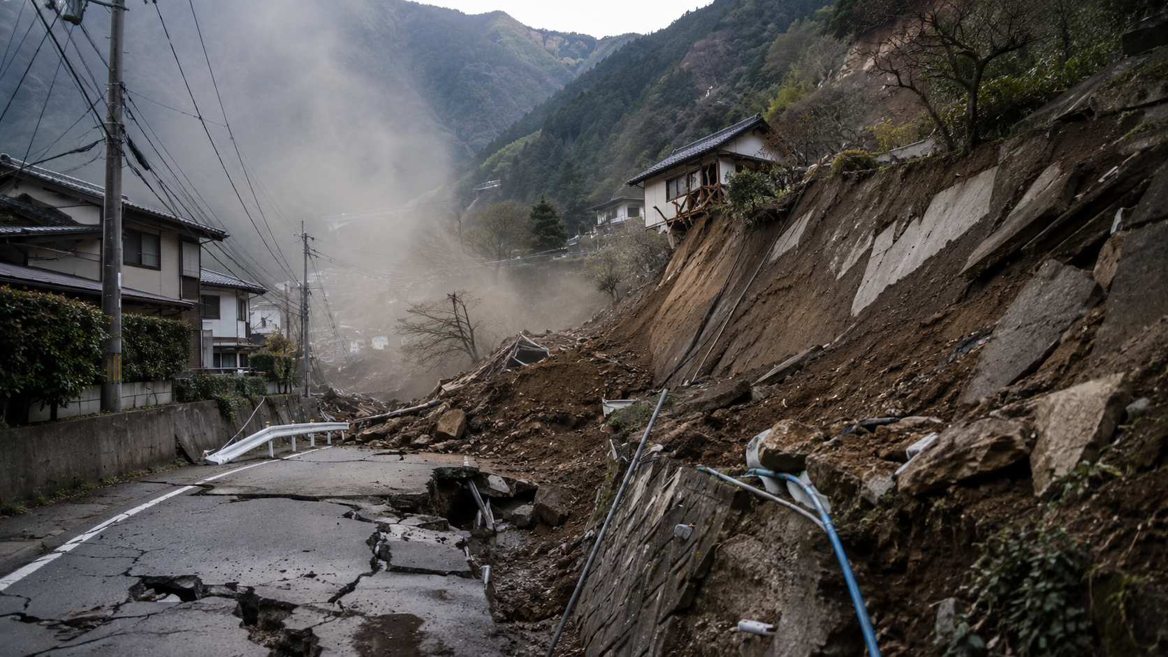
The small signs roads and retaining walls give
Landslides do not always announce themselves dramatically. A new crack appears in the road. Drainage water suddenly turns muddy. Small stones begin falling from a cut slope. A retaining wall bulges. Water runs out of a weep hole with soil in it. A tree leans. A stream changes sound. After an earthquake, especially before or during heavy rain, these small signs matter.
Mountain Japan depends on roads. One prefectural road, one bridge, one tunnel or one local route may connect a community to school, a clinic, a supermarket or a shelter. A landslide does not need to hit a house to stop daily life. It only has to block the way. That is why post-quake inspection must look beyond building damage and include slopes, drainage, embankments, tunnels, bridges and the long thin network that keeps rural Japan connected.
The wider week: Tohoku shaking and disaster fatigue
The Yamanashi quake came in a week that had already reminded Japan of its seismic reality. Reuters reported that a magnitude 6.9 earthquake struck off Japan’s northeast coast on June 25, with no tsunami warning, no immediate injuries reported and no nuclear irregularities found. The strongest shaking was recorded in Aomori at upper 6 on the Japanese intensity scale, and some rail and expressway services were halted for checks.
Disaster fatigue is real. Alerts sound. Phones vibrate. Television maps turn red. Children lose sleep. Older residents hesitate over evacuation. Local officials, firefighters, police, railway companies and road managers keep working through one alert after another. In that atmosphere, Japan’s challenge is not only to respond to each event but to preserve clear judgment for the next one.
What households should check
After a quake, start close to home. Check for gas smell, damaged electrical equipment, unstable furniture, open cupboards, fallen objects, cracked walls and water problems. Outside, look from a safe distance at block walls, gates, roof tiles, storage sheds, retaining walls and slopes. Do not approach a leaning wall or an unstable slope to take a closer look.
For homes near hillsides, watch the ground and water after rain resumes. Muddy water from a slope, sudden changes in drainage, cracking soil, leaning trees, rumbling sounds or falling stones are reasons to leave early. Evacuation does not have to mean a dramatic act. Sometimes it simply means spending one wet night away from the slope.
Japan’s strength is remembering before the next disaster
Japan has built one of the world’s most sophisticated disaster-prevention systems: dense observation networks, seismic engineering, emergency alerts, evacuation planning and public drills. But disasters keep changing shape. This time, the shape was not a giant tsunami or a citywide fire. It was a mountain quake entering a wet, storm-heavy weekend.
News headlines often end with reassuring phrases: no tsunami, limited damage, no major disruption. Those facts matter. But disaster awareness begins again after that sentence. The shaking stops. The rain continues. The roads wait to be checked. The slopes stay quiet.
The Yamanashi–Kanagawa earthquake may not become a major national disaster. But it leaves a useful warning for Japan’s Sunday: sometimes the quake is only the first part of the story.
Sources and references
This article draws on public reporting and disaster-prevention references from The Japan Times, Reuters, the Japan Meteorological Agency, and Yamanashi Prefecture. Conditions after earthquakes and heavy rain can change quickly; readers should follow official local evacuation and road information.
- The Japan Times: Strong earthquake jolts Yamanashi and Kanagawa amid landslide fears.
- Japan Meteorological Agency: Earthquake information.
- Japan Meteorological Agency: Tables explaining the JMA Seismic Intensity Scale.
- Reuters: Magnitude 6.9 quake strikes Japan’s northeast, no tsunami warning.
- The Japan Times: Heavy rain continues across country with two approaching tropical storms.
- Yamanashi Prefecture: Earthquake damage assessment and disaster prevention material.