Wednesday, October 28, 2026 · English Edition日本語 | US$1 = ¥157.50 (October 27, 2026, 04:48 JST; reference rate)
Japan.co.jp
Japan, clearly told.
Wednesday, October 28, 2026Art Choice | Utagawa Sadahide
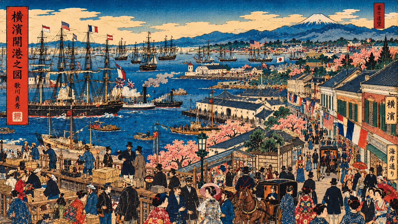
AI-generated original editorial illustration inspired by Sadahide’s Yokohama panoramas
Original AI-generated editorial artwork inspired by Sadahide’s panorama; not the historic print and not a documentary reconstruction. See museum collection links below for the original. Image: Japan.co.jp.
AIYASHI | ART CHOICE
ART CHOICE | YOKOHAMA PRINTS & HISTORY

Utagawa Sadahide: The Artist Who Watched Japan Open to the World

Ships, roads and an entirely new trading port: an eight-sheet panorama captured a national turning point, while raising a timeless question about how pictures become history.

1859Yokohama opens
~1.9mPanorama width
8 sheetsWoodblock composition
1807Artist’s birth year

Sadahide did more than picture a port: he showed how a place was becoming connected to the world.

A city appears across the water

Foreign vessels gather in the harbor. A new settlement rises on the shore. The old Tōkaidō road threads along the opposite coast, while the hills open toward Mount Fuji. Utagawa Sadahide’s enormous panorama, Complete Picture of the Newly Opened Port of Yokohama, offered its first buyers something that no single observer could see from one spot: the entire geography of a Japanese port being refashioned for international commerce. It is both an extraordinary artwork and a remarkably ambitious form of visual reporting.

The opening was a negotiated beginning, not an inevitability

The Port of Yokohama formally opened on July 1, 1859. Yokohama Archives of History notes that the first US treaty specified July 4, while a subsequent treaty with Russia established July 1, the date actually implemented. Foreign diplomats objected to the shogunate’s choice to develop Yokohama rather than the settlement of Kanagawa named in the treaties. The familiar international city grew from decisions contested by governments and merchants, not from a natural, undisputed transition.

Eight sheets and nearly two meters of information

One early example in the Smithsonian’s National Museum of Asian Art, dated 1859, measures roughly 69.5 by 191.1 centimeters. Philadelphia Museum of Art describes its approximately 1860 example as an eight-sheet composite woodcut, one of the largest of its kind issued in Japan. Japanese collections generally date comparable impressions to around 1860; Carnegie Museum of Art gives 1859–1860. These are collection-specific dates and objects, not a claim that every surviving impression was printed in one identical edition.

A viewpoint that is accurate—and impossible

Sadahide’s inscription, interpreted by both Smithsonian and Philadelphia, identifies the outlook from Koyasu village across the water from Yokohama. Yet the picture turns that real vantage point into a sweeping aerial survey. The print makes the foreign settlement, Japanese district, docks, ships, inland roads and distant terrain legible at once. Its power comes from a useful contradiction: an artist staking a claim to observed reality while arranging that reality into a composition no human eye could take in at one instant.

The news medium of the newly opened port

Yokohama-e, the genre of prints portraying the port’s foreign residents, streets, technologies and trade, flourished in the first years after opening. Yokohama Archives of History identifies 1860 and 1861 as particularly active publishing years. These prints met an appetite for visual news from a place most buyers had never visited. But they were commercial products, not neutral photographs: publishers commissioned subjects, artists organized scenes, and specialist carvers and printers translated drawings into multicolored impressions. Their usefulness as historical evidence increases when we remember how they were made.

The artist who learned to see from above

Born in 1807, Sadahide studied under Utagawa Kunisada, later known as Toyokuni III, and worked across portraits, warriors, landscapes, illustrated guides and pictorial maps. He signed works with names including Gountei and Gyokuransai; Japanese museum catalogues also use the name Hashimoto. Yokohama Archives of History says his Yokohama subjects number more than a hundred. His hallmark was the elevated panorama, a way of making unfamiliar places understandable through routes, shorelines and human activity. The opening port gave that method unprecedented relevance.

Silk, foreign merchants and the making of a market

The trade that animated Yokohama had material consequences far beyond the bay. Research published by Yokohama’s heritage institutions traces the rapid rise in raw-silk exports after 1859, followed by silkworm eggs and tea. Japanese traders carried goods to foreign merchant houses; negotiations, inspections and transport tied inland producers to overseas buyers. Seen from this perspective, Sadahide’s roads and waterfront are not picturesque filler. They were the connective tissue of a new export economy—and of new dependencies and disputes.

The divisions inside a cosmopolitan view

According to the Smithsonian’s interpretation of its early impression, larger buildings to the left of the composition designate the residential quarter of foreign nationals, while the Japanese quarter stands toward the right. The post town of Kanagawa sits in the foreground along the Tōkaidō. The view celebrates the town’s extraordinary transformation, yet also records separation. Different zones of residence, unequal diplomatic arrangements and the practical difficulties of exchange formed part of the same historical landscape as the handsome ships.

How much can a beautiful picture prove?

Sadahide’s appeal as a documentarian should not lead viewers to treat every detail as a dated census of buildings or people. Commentary on a different print, View of the New Port of Kanagawa-Yokohama, notes an artful inclusion of cherry trees carried by gardeners to lend beauty to a city that had scarcely had time to grow them. The example demonstrates the artist’s combination of observation and visual invention. Historical use of such images requires comparison with maps, written records and the specific impression at hand.

Even his lifespan is recorded differently

One biographical detail resists tidy certainty. Smithsonian and Carnegie list Sadahide as 1807–1873, while Yokohama Museum of Art and Chiba City Museum of Art give 1807–1878. Oita Prefectural Art Museum records 1807–1879 with a question mark. This article retains the disagreement rather than presenting one date as definitively established. Regardless of the year, the artist’s original nineteenth-century works have passed Japan’s ordinary copyright term.

Public-domain artwork is not the same as every museum image file

Carnegie marks its impression Public Domain, and one Smithsonian archive record displays a CC0 statement. Some Smithsonian collection pages nevertheless display a separate “Usage Conditions Apply” notice. Those differing interfaces make it especially important to check the terms of the exact image one downloads, even when the underlying print is out of copyright. Our hero artwork is an original AI-generated editorial interpretation of Sadahide’s panoramic manner, not a reproduction of the historical eight-sheet print. The source collections linked below allow readers to see the originals.

A newspaper-sized view of transformation

Sadahide’s panoramas were made in an era when a new port could redraw maps of business, identity and power. His accomplishment was not simply to celebrate modernity. It was to make distance manageable: to show how ships connected to wharves, wharves to streets, streets to the old highway and the town to a wider world. The work can still reward modern readers who look at it both admiringly and skeptically. What survives is evidence of how a rapidly changing society chose to picture itself.

Sources and collection records

Museum records and historical archives were compared. Dates, dimensions, and image terms vary by impression and institution. This is historical analysis grounded in extant collection records.

  1. Kanagawa Prefectural Museum of Cultural History: panorama record
  2. Yokohama Museum of Art: collection record and dating
  3. Chiba City Museum of Art: work, reading and artist dates
  4. Yokohama Archives of History: opening of the port
  5. Yokohama Archives: Sadahide’s career and Yokohama prints
  6. Smithsonian NMAA: 1859 impression S1998.58a-h
  7. Smithsonian NMAA: early 1860s impression S2007.5a-j
  8. Carnegie Museum of Art: eight-sheet print and copyright status
  9. Philadelphia Museum of Art: eight-block panorama interpretation
  10. National Institute of Japanese Literature: another Sadahide port print
  11. Yokohama Archives of History: the Yokohama-e genre
  12. Oita Prefectural Art Museum: artist biography and disputed dates
Utagawa Sadahide: The Artist Who Watched Japan Open to the World | Japan.co.jp
Wednesday, October 28, 2026 · English Edition日本語 | US$1 = ¥157.50 (October 27, 2026, 04:48 JST; reference rate)
Japan.co.jp
Japan, clearly told.
Wednesday, October 28, 2026Art Choice | Utagawa Sadahide
AI-generated original editorial illustration inspired by Sadahide’s Yokohama panoramas
Original AI-generated editorial artwork inspired by Sadahide’s panorama; not the historic print and not a documentary reconstruction. See museum collection links below for the original. Image: Japan.co.jp.
AIYASHI | ART CHOICE
ART CHOICE | YOKOHAMA PRINTS & HISTORY

Utagawa Sadahide: The Artist Who Watched Japan Open to the World

Ships, roads and an entirely new trading port: an eight-sheet panorama captured a national turning point, while raising a timeless question about how pictures become history.

1859Yokohama opens
~1.9mPanorama width
8 sheetsWoodblock composition
1807Artist’s birth year

Sadahide did more than picture a port: he showed how a place was becoming connected to the world.

A city appears across the water

Foreign vessels gather in the harbor. A new settlement rises on the shore. The old Tōkaidō road threads along the opposite coast, while the hills open toward Mount Fuji. Utagawa Sadahide’s enormous panorama, Complete Picture of the Newly Opened Port of Yokohama, offered its first buyers something that no single observer could see from one spot: the entire geography of a Japanese port being refashioned for international commerce. It is both an extraordinary artwork and a remarkably ambitious form of visual reporting.

The opening was a negotiated beginning, not an inevitability

The Port of Yokohama formally opened on July 1, 1859. Yokohama Archives of History notes that the first US treaty specified July 4, while a subsequent treaty with Russia established July 1, the date actually implemented. Foreign diplomats objected to the shogunate’s choice to develop Yokohama rather than the settlement of Kanagawa named in the treaties. The familiar international city grew from decisions contested by governments and merchants, not from a natural, undisputed transition.

Eight sheets and nearly two meters of information

One early example in the Smithsonian’s National Museum of Asian Art, dated 1859, measures roughly 69.5 by 191.1 centimeters. Philadelphia Museum of Art describes its approximately 1860 example as an eight-sheet composite woodcut, one of the largest of its kind issued in Japan. Japanese collections generally date comparable impressions to around 1860; Carnegie Museum of Art gives 1859–1860. These are collection-specific dates and objects, not a claim that every surviving impression was printed in one identical edition.

A viewpoint that is accurate—and impossible

Sadahide’s inscription, interpreted by both Smithsonian and Philadelphia, identifies the outlook from Koyasu village across the water from Yokohama. Yet the picture turns that real vantage point into a sweeping aerial survey. The print makes the foreign settlement, Japanese district, docks, ships, inland roads and distant terrain legible at once. Its power comes from a useful contradiction: an artist staking a claim to observed reality while arranging that reality into a composition no human eye could take in at one instant.

The news medium of the newly opened port

Yokohama-e, the genre of prints portraying the port’s foreign residents, streets, technologies and trade, flourished in the first years after opening. Yokohama Archives of History identifies 1860 and 1861 as particularly active publishing years. These prints met an appetite for visual news from a place most buyers had never visited. But they were commercial products, not neutral photographs: publishers commissioned subjects, artists organized scenes, and specialist carvers and printers translated drawings into multicolored impressions. Their usefulness as historical evidence increases when we remember how they were made.

The artist who learned to see from above

Born in 1807, Sadahide studied under Utagawa Kunisada, later known as Toyokuni III, and worked across portraits, warriors, landscapes, illustrated guides and pictorial maps. He signed works with names including Gountei and Gyokuransai; Japanese museum catalogues also use the name Hashimoto. Yokohama Archives of History says his Yokohama subjects number more than a hundred. His hallmark was the elevated panorama, a way of making unfamiliar places understandable through routes, shorelines and human activity. The opening port gave that method unprecedented relevance.

Silk, foreign merchants and the making of a market

The trade that animated Yokohama had material consequences far beyond the bay. Research published by Yokohama’s heritage institutions traces the rapid rise in raw-silk exports after 1859, followed by silkworm eggs and tea. Japanese traders carried goods to foreign merchant houses; negotiations, inspections and transport tied inland producers to overseas buyers. Seen from this perspective, Sadahide’s roads and waterfront are not picturesque filler. They were the connective tissue of a new export economy—and of new dependencies and disputes.

The divisions inside a cosmopolitan view

According to the Smithsonian’s interpretation of its early impression, larger buildings to the left of the composition designate the residential quarter of foreign nationals, while the Japanese quarter stands toward the right. The post town of Kanagawa sits in the foreground along the Tōkaidō. The view celebrates the town’s extraordinary transformation, yet also records separation. Different zones of residence, unequal diplomatic arrangements and the practical difficulties of exchange formed part of the same historical landscape as the handsome ships.

How much can a beautiful picture prove?

Sadahide’s appeal as a documentarian should not lead viewers to treat every detail as a dated census of buildings or people. Commentary on a different print, View of the New Port of Kanagawa-Yokohama, notes an artful inclusion of cherry trees carried by gardeners to lend beauty to a city that had scarcely had time to grow them. The example demonstrates the artist’s combination of observation and visual invention. Historical use of such images requires comparison with maps, written records and the specific impression at hand.

Even his lifespan is recorded differently

One biographical detail resists tidy certainty. Smithsonian and Carnegie list Sadahide as 1807–1873, while Yokohama Museum of Art and Chiba City Museum of Art give 1807–1878. Oita Prefectural Art Museum records 1807–1879 with a question mark. This article retains the disagreement rather than presenting one date as definitively established. Regardless of the year, the artist’s original nineteenth-century works have passed Japan’s ordinary copyright term.

Public-domain artwork is not the same as every museum image file

Carnegie marks its impression Public Domain, and one Smithsonian archive record displays a CC0 statement. Some Smithsonian collection pages nevertheless display a separate “Usage Conditions Apply” notice. Those differing interfaces make it especially important to check the terms of the exact image one downloads, even when the underlying print is out of copyright. Our hero artwork is an original AI-generated editorial interpretation of Sadahide’s panoramic manner, not a reproduction of the historical eight-sheet print. The source collections linked below allow readers to see the originals.

A newspaper-sized view of transformation

Sadahide’s panoramas were made in an era when a new port could redraw maps of business, identity and power. His accomplishment was not simply to celebrate modernity. It was to make distance manageable: to show how ships connected to wharves, wharves to streets, streets to the old highway and the town to a wider world. The work can still reward modern readers who look at it both admiringly and skeptically. What survives is evidence of how a rapidly changing society chose to picture itself.

Sources and collection records

Museum records and historical archives were compared. Dates, dimensions, and image terms vary by impression and institution. This is historical analysis grounded in extant collection records.

  1. Kanagawa Prefectural Museum of Cultural History: panorama record
  2. Yokohama Museum of Art: collection record and dating
  3. Chiba City Museum of Art: work, reading and artist dates
  4. Yokohama Archives of History: opening of the port
  5. Yokohama Archives: Sadahide’s career and Yokohama prints
  6. Smithsonian NMAA: 1859 impression S1998.58a-h
  7. Smithsonian NMAA: early 1860s impression S2007.5a-j
  8. Carnegie Museum of Art: eight-sheet print and copyright status
  9. Philadelphia Museum of Art: eight-block panorama interpretation
  10. National Institute of Japanese Literature: another Sadahide port print
  11. Yokohama Archives of History: the Yokohama-e genre
  12. Oita Prefectural Art Museum: artist biography and disputed dates