Do not read this storm as only a line on a map
The easiest mistake with Typhoon Mekkhala is to stare only at the center track. Of course, the track matters. A storm passing just west of Okinawa is different from a storm staying far out over the Philippine Sea. A storm curving along Japan’s southern coast is different again. But in Japan’s rainy season, typhoon damage is often decided not only by the eye, the center or the headline wind speed. It is decided by moisture, fronts, mountains, saturated ground and timing.
Late June Japan is already wet. The baiu rainy-season front lingers. Hillsides have absorbed rain. Rivers react faster. Low-lying districts become sensitive to drainage limits. Then warm, humid air from a typhoon arrives from the south. Rain can come before the center. The swirl on the map may still look far away while drains, streams and railways begin to care very much.
The Guardian reported on June 22 that Mekkhala had strengthened east of Luzon and was expected to move north through the Philippine Sea, potentially peaking around Tuesday and Wednesday. The storm may weaken before approaching southern Japan, perhaps to a tropical storm or even an extra-tropical depression. But the important sentence is the next one: existing heavy rainfall over Japan could interact with ex-Mekkhala and intensify, bringing a flood threat.
What is Mekkhala? The angel of thunder over the Philippine Sea
The name Mekkhala was contributed by Thailand and is often explained as the “angel of thunder.” The western Pacific uses a rotating list of names contributed by countries and territories in the WMO/ESCAP Typhoon Committee system. Japan often uses typhoon numbers domestically, but names matter internationally. Ships, airlines, insurers, forecasters and emergency officials need to know they are talking about the same storm.
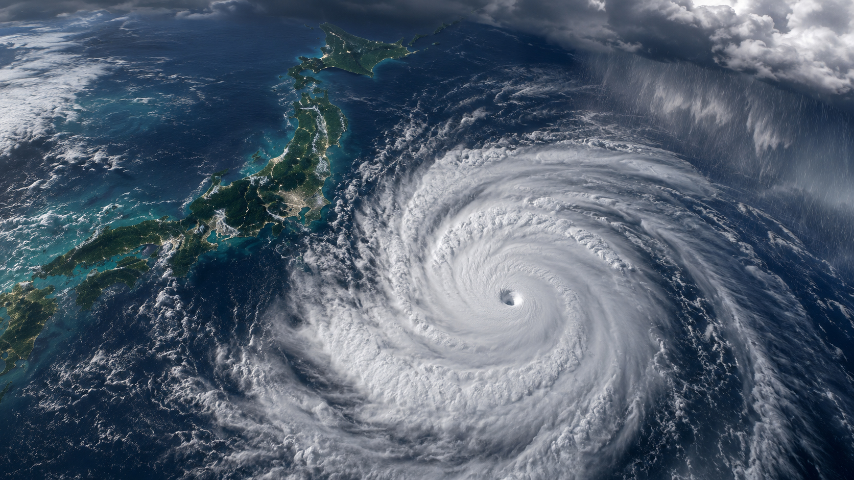
At 03:00 JST on June 23, the Japan Meteorological Agency listed Mekkhala as a very strong typhoon centered near 18.5 degrees north and 125.8 degrees east, moving west-northwest at 15 km/h. Weathernews, using JMA observations from June 22 at 06:00 UTC, described the storm as having a central pressure of 935 hPa, maximum sustained winds of 50 m/s and gusts of 70 m/s. Even before any Japan impact, those are serious open-water numbers.
Stars and Stripes’ Pacific Storm Tracker said Mekkhala had slowed just shy of super-typhoon intensity while still forecast to approach Okinawa late in the week, potentially near Kadena on Friday with heavy rain and strong winds. The same outlook noted a possible northeastward track near Japan’s southern coastline later in the weekend, with implications not only for Okinawa but also for the Kanto area if the track and frontal zone line up.
Okinawa and the southwestern islands: wind, waves, ports and planes
For travelers, the first practical risk may be transport rather than rain. Okinawa, Ishigaki, Miyako and Amami depend on airports and ports. Aircraft are sensitive to winds, lightning and visibility. Ferries are sensitive to waves and swell. Port work is sensitive to gusts and sea state. The storm center can be offshore and still make the sea unusable first.
Weathernews published a maritime outlook for the Okinawa region, focusing on port-specific operational risks for places such as Naha, Kinwan and Ishigaki. For a tourist, that does not simply mean “no beach today.” It can mean a canceled return flight, a delayed ferry, a rental car schedule that no longer works, or an unexpected hotel extension. A tropical vacation can quickly become an exam in timetables and cancellation rules.
Okinawa knows typhoons. Its buildings, local governments and residents have experience. But experience is not the same as safety for visitors. In fact, the more a region is used to storms, the easier it is for outsiders to misunderstand the risk. “Just a quick look at the sea” is among the most expensive thoughts a traveler can have during a typhoon. Coral-blue water changes personality very quickly when swell and wind arrive.
Mainland Japan: the rain can get worse after the storm weakens
People on Honshu may hear that a strong storm is near Okinawa and feel there is still plenty of distance. In rainy-season Japan, that can be the wrong comfort. Sometimes the dangerous phase comes as the typhoon weakens and its moisture becomes entangled with a stationary front. The word “typhoon” may fade. The water vapor does not. The mountains do not. The rivers do not.
If the rainy-season front sits near the main islands and Mekkhala’s moisture feeds into it, rain clouds may keep redeveloping over the same areas. The Pacific-facing mountain slopes of Kyushu, Shikoku, the Kii Peninsula, Tokai and Kanto are always worth watching in this pattern. Japan’s terrain acts like a wall. Moist air hits mountains, rises, cools and makes rain. Rivers rise faster than flatland visitors expect.
A slight southward shift could keep the worst offshore. A northward nudge could put heavy rain over land. A slower storm could lengthen the rain window. Japanese flood disasters often come from the sum of a front, terrain, moisture and rain already on the ground, not simply from one dramatic eyewall. To understand Mekkhala, you must read not only the swirl but the archipelago underneath it.
Why Japan is vulnerable to rain: mountains, rivers and cities
Japan is a water-rich country. It is also a country that can be cornered by water. Much of the land is mountainous. Rivers are short and steep. The flat spaces are densely urbanized. Rain that falls on mountains gathers quickly into valleys, drops into rivers and then reaches plains where people, roads, railways and factories are concentrated.
Major cities such as Tokyo, Osaka, Nagoya and Fukuoka have sophisticated drainage systems. But extreme rainfall can exceed the assumptions of older infrastructure. Underground malls, subway entrances, underpasses, low-lying neighborhoods, riverside industry and port logistics all become part of the storm map. A convenient city can become vulnerable when water has nowhere else to go.
Rural Japan faces another kind of risk. Elderly residents may need more time to evacuate. Volunteer fire corps and local emergency teams are aging. A landslide on one mountain road can isolate a village. Bus and rail alternatives may be limited. That is why a typhoon story should not end as a simple travel advisory. It is also a story about Japan’s regional infrastructure and its aging communities.
Isewan, Hagibis and the memory of water
Japanese typhoon history carries names that should not be forgotten. The 1959 Isewan Typhoon reshaped modern disaster policy after storm surge and violent weather caused catastrophic damage. It was one of the disasters that pushed Japan toward stronger national disaster laws and modern warning systems.
Typhoon Hagibis in 2019 is a more recent reminder. Record rainfall across wide areas triggered river flooding, landslides and urban inundation. Typhoons come from the sea, but damage happens in the details: levees, drainage channels, evacuation centers, phone warnings, family calls, pet plans and the road behind the house. A disaster is a huge natural event breaking small pieces of daily life one by one.
This does not mean Mekkhala is another Isewan or Hagibis. The point is not comparison by scale. The point is the way of seeing. A weakening typhoon can still feed a front. A region far from the center can still flood. Landslides can occur after the rain eases. A typhoon is not over the moment the center passes.
A practical map for travelers: what to check
Travelers need usable information, not panic. First, check JMA for track, wind areas and forecast cones. Second, check local government evacuation information. Third, check airlines, railways, ferries and expressway operators. Fourth, ask hotels about extensions and cancellation rules before everyone else is asking the same question.
In Okinawa and Amami, air and sea transport often become the first constraints. In Kyushu, Shikoku, the Kii Peninsula, Tokai and Kanto, rainfall totals and river levels may matter more. At mountain hot springs, campgrounds and rural inns, the key issue may be whether there is only one road out. A radar screen that looks acceptable near you does not tell you what is happening upstream.
Foreign visitors should be especially careful with language barriers. Use hotel staff, official English pages, station staff and airline information. A very Japan.co.jp travel rule: the best sightseeing during a typhoon is the kind that does not require heroism. Temples, castles, hot springs and beaches will still be there tomorrow. It is better if your knees, phone and passport are there tomorrow too.
| Area | Main risks | What to check |
|---|---|---|
| Okinawa / southwestern islands | Strong winds, high seas, port closures, flight cancellations, power outages | JMA typhoon data, airport and airline notices, ferry status, local government updates |
| Amami / southern Kyushu | Heavy rain, landslides, river rises, coastal swell | Rain radar, landslide warnings, roads and railways |
| Shikoku / Kii Peninsula / Tokai | Orographic rain, long-duration rainfall, mountain landslides | Accumulated rainfall, river gauges, evacuation advisories |
| Kanto / southern Tohoku | Track-dependent weekend rain and wind, transport disruption, lowland flooding | Typhoon track, front position, railway and highway information |
“Weakening” is not the same as “safe”
When forecasts say a typhoon may weaken before nearing Japan, people relax. Understandably. A weaker storm is better than a stronger one. But in disaster language, “weakening” needs caution. Wind danger may fall while rain danger remains. The center may lose structure while the rain shield expands. An extra-tropical transition can spread impacts across a wider area if it couples with a front.
With Mekkhala, watch more than one number. Watch the east-west spread of the forecast, the forward speed, the rainy-season front, rainfall already on the ground, sea swell, tides and transport decisions. A typhoon is not only a monster in the sky. It is a weather system touching roads, rails, ports, rivers, hotels and households.
The most useful disaster habit in Japan is to move one step before “it is definitely bad.” Charge the phone. Find the flashlight. Check medicine. Buy water. Delay the trip. Stay away from the sea. Do not go look at the river. Message the family. The boring preparation is the one people are grateful for later.
- Mekkhala is moving north through the Philippine Sea as a strong typhoon, but may weaken before nearing southern Japan.
- Even a weakening system can raise flood and landslide risk if its moisture feeds Japan’s rainy-season front.
- For Okinawa and the southwestern islands, wind, waves, flights, ferries and port operations are central risks.
- For mainland Japan, the center track matters less than the interaction between moisture, terrain and the baiu front.
- Travelers should prioritize official JMA, local government, airline, railway and ferry information over social media track maps.
Sources and references
This article uses public information from the Japan Meteorological Agency, The Guardian, Stars and Stripes, Weathernews, WMO, MLIT and JMA historical typhoon records. Typhoon tracks and warnings change quickly. For travel, shipping, evacuation or safety decisions, always check the latest updates from JMA, local governments and transport operators.
- Japan Meteorological Agency: Typhoon Mekkhala information
- Japan Meteorological Agency: Tropical Cyclone Information map
- The Guardian: Weather tracker — typhoon strengthens off the Philippines
- Stars and Stripes: Pacific Storm Tracker, Typhoon Mekkhala
- Weathernews: Typhoon Mekkhala severe weather outlook and Okinawa port forecasts
- World Meteorological Organization: tropical cyclone naming
- Ministry of Land, Infrastructure, Transport and Tourism: disaster timelines
- JMA: Typhoon Hagibis / 2019 heavy rain record