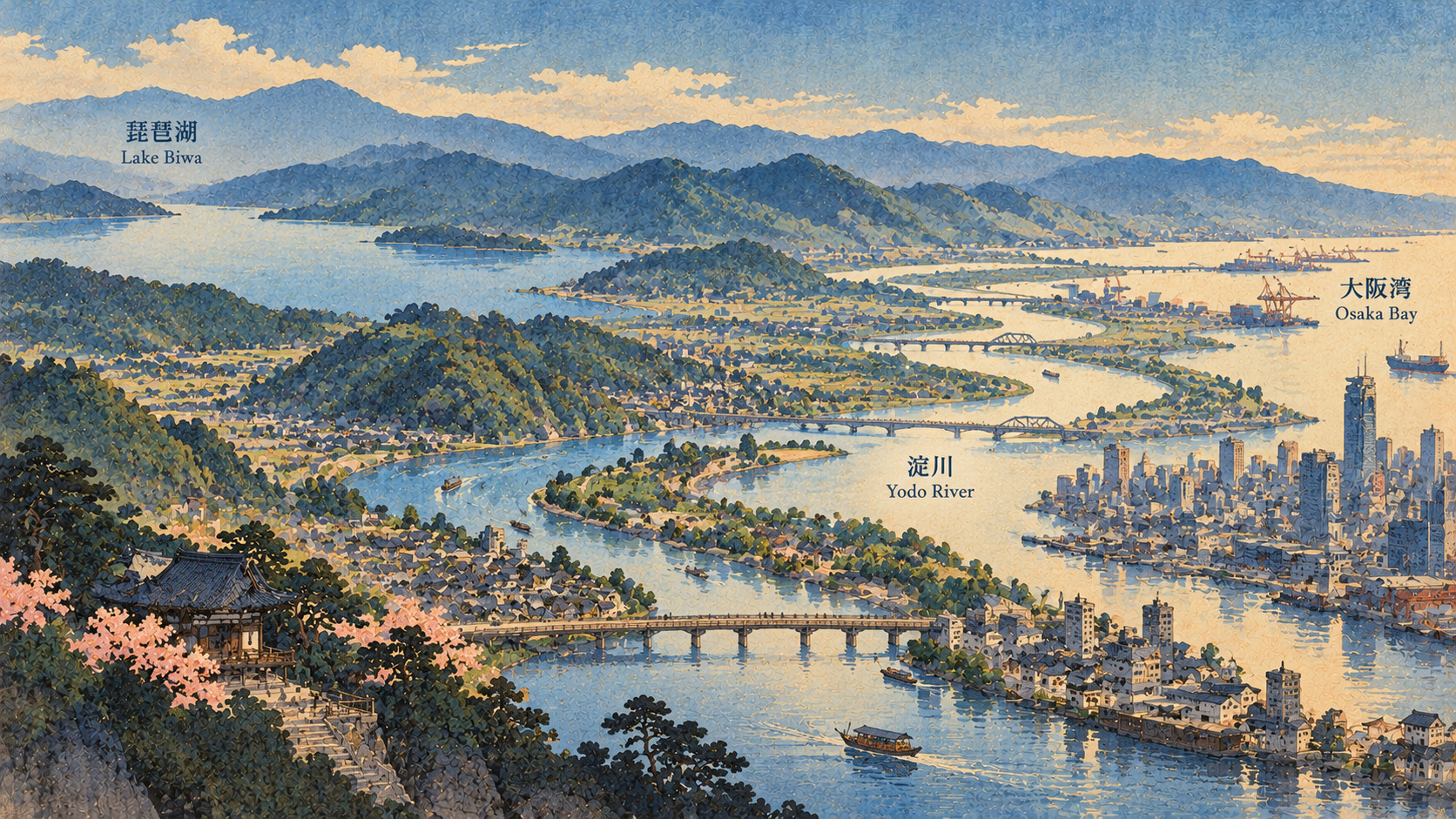
The river built the city. The city rebuilt the river. Now comes a new question: who is the waterfront for?
The waterway hiding in plain sight
A new free exhibition opened November 1 beneath Osaka’s Hachikenya river station, presenting the Lake Biwa–Yodo River basin as something more than a line on a map. Titled “Mizube o Tabi Shiyō: Minna no Kawamachizukuri o Meguru” (roughly, “Travel the Waterfront: Exploring Everyone’s River-and-Town Placemaking”), it runs through December 15. Organized by the Kinki Regional Development Bureau and Osaka Prefecture, the show uses terrain models, explanatory panels and a visitor vote to ask how riverbanks can become useful civic spaces again.
A lake, three rivers and an urban bay
The journey begins with Lake Biwa in Shiga Prefecture. Water leaves the lake through the Seta River, flows as the Uji River through Kyoto Prefecture and meets the Kizu and Katsura rivers. From their confluence the Yodo continues across the Osaka plain toward Osaka Bay. Each section belongs to the same watershed, but conditions differ enormously: lake levels, upstream tributaries, dams, historic towns, urban floodplains and the coast. A visitor admiring a promenade in Osaka is therefore looking at only the last part of a complex shared system.
Why Hachikenya is a fitting venue
The exhibition’s location is not arbitrary. Hachikenya-hama, near modern Temmabashi, has a long association with river transport between Kyoto and Osaka. In the Edo period, passenger and freight boats used the waterfront; the celebrated thirty-koku passenger boats became part of the popular memory of travel on the Yodo. Railway lines and highways eventually displaced much of that traffic. Today’s waterfront revival is not an attempt to restore the old shipping economy unchanged. It is a search for new uses—public access, urban walking routes, recreation and education—on shores that once kept a commercial city moving.
The remarkable 150-year engineering story
The ministry’s Yodo River 150-Year History, published in February 2026, traces modern improvement works back to 1874, when engineers including the Dutch specialist Johannis de Rijke helped shape river projects associated with navigation. After the devastating 1885 flood, reconstruction and improvement expanded. Major works launched in 1896 included a new Yodo channel and control structures associated with the Seta and Kema waterways. Rivers are often presented either as untamed natural wonders or as pieces of engineering. The Yodo makes clear that they have long been both.
The disasters that shaped the modern river
Flood management has repeatedly driven major changes. The ministry chronicles the 1885 inundation, a further destructive flood in 1917 and the failure of a Uji River embankment during Typhoon No. 13 in 1953. Later works involved embankments, dams, weirs and management of the Seta River outlet—the only natural outlet from Lake Biwa. Such interventions helped safeguard lives and property, but also reshaped habitats, landscapes and how residents encounter the river. Any persuasive story about pleasant new waterfronts needs to remember the less picturesque history of flood risk.
What “kawamachizukuri” really means
The program’s key word, kawamachizukuri, means bringing river space and urban or town space together to create appealing, accessible waterfronts. It can involve public paths, piers, cultural programming or a clearer connection between a river and surrounding streets. It is not synonymous with a single new construction contract, and the exhibition does not announce a newly completed river project. The featured models and panels describe work across the Lake Biwa–Yodo watershed. Whether a given project succeeds requires local evidence: accessibility, safety, ongoing maintenance and use outside festivals.
Fourteen years of explaining the waterfront
According to the Kinki Regional Development Bureau, the Hi ship! Project has mounted an exhibition at Hachikenya every fiscal year since 2013. In 2026 its theme is river-and-town placemaking. That continuity matters. Riverfront renewal is a cumulative civic endeavor, involving residents, municipal officials, businesses and river managers who must often coordinate across boundaries. Still, continuity in exhibition programming is not itself proof that visitor numbers, neighborhood revenue or ecological conditions have improved. Those outcomes require separate evaluation.
A model you can walk around, and a vote you can cast
The organizers plan topographic models of the basin, panels highlighting initiatives and a popularity vote asking which waterfront placemaking locations visitors most want to explore. Such devices can make unfamiliar regional geography tangible, especially for families and school-age visitors. A poll in an exhibition is an invitation to engage, not a scientifically representative assessment of the most effective project. It would be misleading to present an eventual visitor ranking as a government investment decision or as an established regional success metric.
From gallery to riverboat on November 23
The Hachikenya venue also advertises a separate family-oriented cruise on November 23, scheduled to run approximately two and a half hours from Hachikenya-hama toward Juso. The planned route includes the Kema lock and the Yodo Gateway structure. For participants, moving through a lock can make visible the infrastructure that ordinarily disappears into the background of city life. The cruise is a related event, not part of admission to the free exhibition; availability, weather restrictions and booking conditions should be checked directly with the organizer.
What Lake Biwa and Osaka owe each other
The region’s hydrology links communities with sometimes different priorities. High lake levels, controlled releases, downstream floods, environmental protection and reliable water supplies cannot be handled as isolated local concerns. The ministry records the 2013 Typhoon No. 18 emergency operations and a revision to the Yodo basin river improvement plan in 2021. A changing climate adds urgency to both flood and drought planning, although the exhibition announcement itself makes no claim to have solved these challenges. The best reading of the event is as an introduction to cooperation, not a new flood-control guarantee.
How to judge a successful revived waterfront
A busier riverfront can be good news, but an event crowd is only one measure. Can residents with limited mobility get close to the water? Is there useful public space on an ordinary weekday? Are maintenance costs sustainable? Does the project reduce or increase pressure on habitat? Can emergency access and flood protection coexist with recreation? These are the questions the next generation of river-and-town planning must answer. The exhibition offers points of comparison, but does not independently establish the economic or environmental performance of every site.
Practical details—and a reason to go
The exhibition runs from Sunday, November 1 through Tuesday, December 15, 2026, 10 a.m.–5 p.m., on the basement level of Kawanoeki Hachikenya, 1-2 Kitahamahigashi, Chuo Ward, Osaka. Admission is free. The venue is roughly five minutes on foot from Temmabashi Station on either the Keihan or Osaka Metro networks, according to organizers. For visitors, the most rewarding approach may be to begin with the watershed model and then step outside toward the very riverfront whose story the gallery is trying to tell.
Primary sources and reporting notes
Dates, venue and content checked against the organizer and venue; engineering history checked against ministry records. Attendance and program impact have not been independently established.
- 近畿地方整備局・2026年10月30日発表 / Official exhibition announcement
- 川の駅はちけんや・企画展案内 / Official venue listing
- 近畿地方整備局『淀川百五十年史』 / Yodo River 150-year history
- 近畿地方整備局・淀川水系の河川改修沿革 / Yodo River basin engineering timeline
- 淀川河川事務所・昭和以降の治水 / Modern flood-control history
- 川の駅はちけんや・11月23日舟運体験 / November 23 cruise
- 琵琶湖河川事務所・2026年発表 / Lake Biwa River Office updates