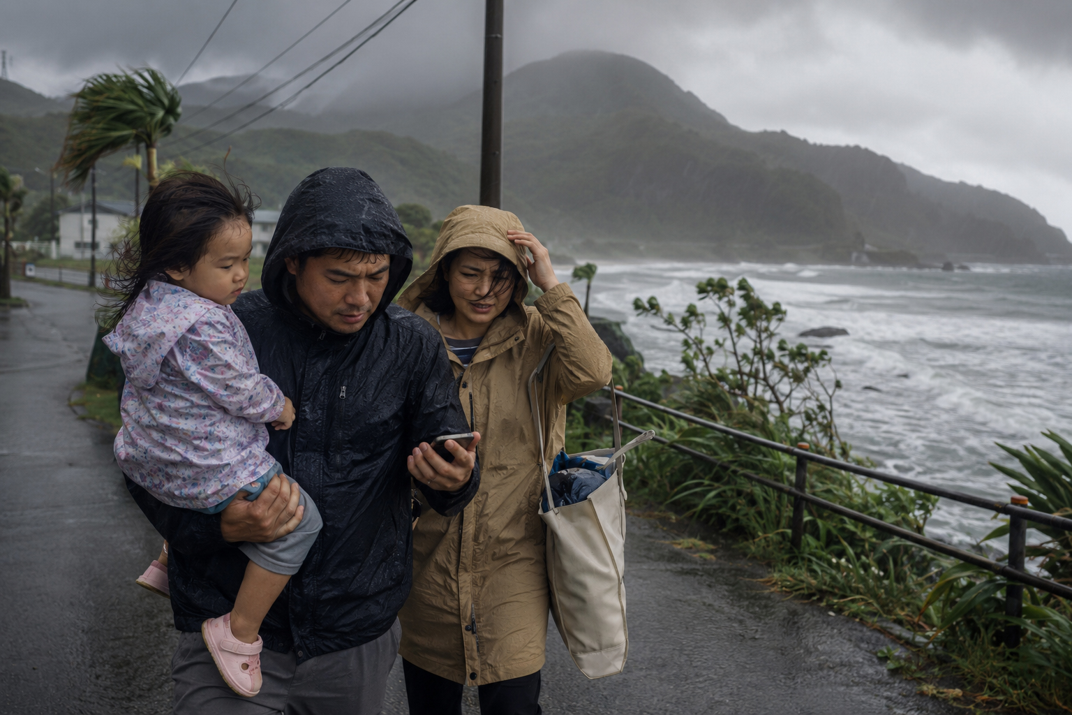
When people hear that a typhoon is weakening, they often relax. The maximum wind speed drops. The central pressure rises. The word “very strong” may disappear from the forecast. But in Japan, the dangerous part of a typhoon is often not limited to its peak wind speed. A weakening storm can still carry enormous moisture. Its waves can still reach the coast. Its rain can still fill rivers. Its water can still loosen slopes. Its danger can arrive after the headline has softened.
In late June 2026, Japan is watching two tropical systems, including Typhoon Mekkhala. Mekkhala has drawn attention as it tracks from the waters east of the Philippines toward the Taiwan–Ryukyu–southern Japan side of the western Pacific. Another tropical system, together with seasonal fronts and humid air, may also increase rainfall risk near Japan. The important question is not only whether a storm makes landfall. In Japan, a storm offshore can still produce heavy rain, landslides, flooding, dangerous seas, travel disruption and delayed river rise.
Storm strength and human risk are not the same thing
Typhoon forecasts report central pressure, maximum sustained winds, maximum gusts, direction of movement, speed, storm-warning areas and forecast circles. These are essential. For ships, aircraft, ports, islands and exposed coasts, wind and wave information can be life-or-death information. But for people on land, the most damaging hazards often come from water.
Japan’s geography turns rain into danger quickly. The country is mountainous, its rivers are often short and steep, and many towns sit in narrow coastal plains or along river valleys. Rain falling in the mountains can collect rapidly into streams and rivers. In cities, asphalt and concrete prevent water from soaking into the ground, so drainage systems can be overwhelmed. In rural areas, hillsides, valleys, farm roads, cut slopes and mountain communities can become landslide zones.
That is why “the center is far away,” “the typhoon is weakening,” or “it may become an extratropical low” are not enough to judge safety. Moist tropical air can feed a seasonal front and produce heavy rain far from the storm center. Rivers can keep rising after the rain peak because water from upstream is still moving downstream. Slopes can fail after hours of saturation, even after the sky looks calmer.
Mekkhala and the second system: do not read only the track line
JMA tropical cyclone information for Mekkhala shows position, category, movement, central pressure, maximum wind, gust speed, forecast circles and storm-warning areas. A forecast circle means the storm center is likely to be somewhere inside that circle at the forecast time. It does not mean hazards stop at the edge of the circle. Rain, swell, high waves, storm surge and humid inflow can extend beyond the center track.
The Associated Press reported that Mekkhala threatened the northern Philippines with flooding, landslides and rough seas even while remaining offshore. That same lesson applies to Japan. A storm does not have to cross your town to affect your town. Broad rain bands, long-period swell, coastal waves, storm surge and interaction with fronts can spread risk far from the eye or center.
For the second tropical system, the name or technical classification is less important than the water vapor it carries. Tropical storm, typhoon, tropical depression, extratropical low, front: the labels can change, but the moisture does not simply disappear. Former typhoons can still bring heavy rain and strong winds after transition.
How to read JMA warnings and local evacuation information
JMA’s warning and advisory system includes heavy rain, flood, storm, high waves, storm surge, thunderstorm and other hazards. On a typhoon day, do not look only at the typhoon track. Check the warning page for your municipality, the heavy-rain risk maps, landslide risk, flood risk, river information, coastal warnings and local government evacuation notices.
Japan has also reorganized disaster-prevention weather information for river flooding, heavy rain, landslides and storm surge into clearer hazard names and five risk levels. JMA’s 2026 English leaflet emphasizes checking current risk levels by color and evacuating from dangerous areas by Level 4. These colors are not decoration. They are action signals.
The roles are different. JMA communicates weather and hazard risk. Municipal governments issue evacuation information. When a local government issues an Evacuation Instruction at Alert Level 4, people in dangerous areas should evacuate immediately or shelter safely if outdoor evacuation is already more dangerous. Level 5 is not a goal to wait for; it means life-threatening conditions may already be occurring.
| Information | What to check | Action |
|---|---|---|
| Typhoon information | Center position, intensity, forecast circle, wind, waves and coastal exposure. | Plan early for ferries, flights, ports, islands and coastal travel. |
| Heavy-rain warnings and risk maps | Rain intensity, expected rainfall, landslide and inundation risk. | Move away from low ground and slopes before travel becomes dangerous. |
| Flood and river information | River levels, upstream rainfall, overflow risk. | Do not go to rivers, bridges or riverbanks to check conditions. |
| Municipal evacuation notices | Alert Level 3, Level 4 and Level 5 local instructions. | At Level 4, evacuate from dangerous areas. Do not wait for Level 5. |
Do not go to the river. Do not check the boat.
Every heavy-rain disaster repeats a dangerous pattern. Someone goes to check the river. Someone checks an irrigation canal. Someone tries to secure a boat. Someone walks to the coast to see the waves. Someone drives into an underpass or across a flooded road because it “looks passable.” These are not safety checks. They are entries into danger.
Rivers cannot be judged by the water level you see at one moment. Heavy upstream rain can produce sudden downstream rise. Muddy water hides edges, drains, open manholes, holes, debris and road damage. Cars can stall in shallower water than drivers expect. Doors may not open against water pressure. A bridge that was safe earlier may not be safe later.
Boats and harbors are the same. The desire to check mooring lines is understandable. But strong wind, waves, storm surge, slippery piers and flying debris can turn a quick check into a rescue. Secure boats and equipment before conditions deteriorate. Once warnings are in effect, protect life before property.
Underpasses and underground spaces are urban traps
In cities, one of the most underestimated hazards is the underpass. Underground malls, basement shops, underground parking, subway entrances and semi-basement homes are also at risk. Water moves to low places. Once a road floods, an underpass can quickly become a tank. From inside a car, the depth is difficult to judge until it is too late.
Tokyo’s multilingual disaster guidance advises people who must go outside during heavy rain to avoid underpasses, rivers, manholes, mountains, cliffs and cars. That advice applies well beyond Tokyo. It is a national urban-safety principle.
If you are in an underground space and sudden heavy rain begins, move above ground early. Once water enters, stairs and escalators can become channels. In stations and commercial buildings, follow staff instructions. Elevators may stop during power failures, so stairs may be safer when evacuation is required.
Landslides can occur after the rain stops
People living near mountains, cliffs, slopes, valleys, cut slopes or embankments must think not only about rainfall intensity but about the time the ground has been absorbing water. Some slopes fail suddenly after long saturation. The sky may be brighter. The rain may be weaker. The ground may still be dangerous.
Possible warning signs include falling stones, cracks in the ground, muddy spring water, sudden changes in stream color, water emerging from slopes or unusual rumbling sounds. But people should not wait for these signs. By the time they appear, evacuation time may be short.
JMA’s heavy-rain safety leaflet says that if evacuation is difficult during landslide risk, people should move to a room away from mountains and steep slopes. For flooding, heavy rain or storm surge, they should move to higher ground as much as possible. This is a last-resort safety action. The better choice is early evacuation before darkness, wind and flooding make travel dangerous.
What travelers and foreign residents should check first
Travelers often lack local knowledge. They may not know which river rises quickly, which road floods, whether a hotel backs up against a slope, or whether the route to the station includes an underpass. That is why they should check hotel staff, station announcements, local government websites, the Safety tips app, JMA multilingual pages and NHK WORLD-JAPAN.
When evacuation information is issued, observing what local residents do can help, but do not assume that inaction means safety. Risk depends on exact location, building type, floor level, distance from rivers or slopes, mobility, family needs and transportation. In hotels, ask about shelters, power outages, elevator stoppages, food, water, emergency exits and transport changes.
At seaside hotels, do not go out to watch waves. On islands and in port towns, assume ferry cancellations can last longer than expected. At mountain inns, check landslide hazard areas. In big cities, consider the risk of flooded underground passages and move to a safe building above ground when instructed.
What households can do now
Typhoon preparation is about sequence more than special gear. First information. Then water and power. Then evacuation routes. Then outdoor hazards. Before winds strengthen, bring in laundry poles, planters, signs, tools, trash bins, bicycles and anything that can fly. Sleep away from windows. Charge phones, mobile batteries, radios and lights.
Place a go-bag near the entrance if evacuation may be needed. Keep shoes near the bed. Families with children, older people, people with disabilities or pets need more time. Level 3 is the time for people who need extra time to start moving from dangerous areas. Waiting until Level 4 may be too late for some households.
Decide how family members will communicate. Calls may not connect during disasters. Use Disaster Emergency Message Dial 171, Web171, messaging apps, a meeting point and an out-of-area relative as a contact hub. Do not rely on only one app. Keep important phone numbers on paper in case batteries die.
What companies, schools and shops should decide
When organizations delay decisions, they push people into dangerous travel. Companies should not say only “come if you can.” They should look at rain, rivers, landslides, wind, power, rail service and return-home risk, then make early decisions on telework, closure or staggered departure. Schools and cram schools should consider whether dismissal time will overlap with peak rain. Restaurants and shops should prioritize employee return routes.
Logistics, construction, ports, tourism, agriculture and fisheries face hard decisions, but sending people to check sites, equipment or vessels after warnings are issued can create secondary disasters. Prepare early. Withdraw early. A good disaster policy is not bravery; it is procedure.
History’s lesson: typhoon disasters are not only wind stories
Japan’s typhoon history shows that water and ground failure often create the most devastating outcomes. The 1959 Isewan Typhoon demonstrated the danger of storm surge. Typhoon Hagibis in 2019 brought widespread record rainfall and river flooding. More recent storms have produced landslides, swollen rivers, road collapses, power outages and transport shutdowns even after weakening or passing offshore.
That history should change how people read the news. Do not look only at category or wind speed. Look at where the rain will fall, which rivers are rising, which slopes are saturated, which roads may close, which trains or flights may stop, and which municipality has issued evacuation instructions. A typhoon is not just a weather-system story. It becomes a disaster through terrain, infrastructure and human decisions.
The rule: do not go see the danger; create safety early
When two tropical systems may influence Japan’s weather, the goal is not to panic. The goal is to choose information sources, identify places not to go, and act early. Do not go to rivers. Do not go to the sea. Do not check boats. Do not drive through underpasses. Do not remain underground when flooding is possible. Do not approach cliffs or mountains during landslide risk.
Follow local evacuation information. Alert Level 4 means evacuate from dangerous areas. Level 5 is not a deadline. It is a sign that danger may already be unfolding.
A weakening typhoon is a change on a weather chart. It is not proof that life is safe. As long as rain, rivers, slopes, seas and roads remain dangerous, the storm is not over.
- Do not go to rivers, irrigation canals, harbors, boats, cliffs, mountains or underpasses to check conditions.
- Follow local evacuation information. At Alert Level 4, evacuate from dangerous areas.
- Charge phones, power banks, flashlights and radios before power outages occur.
- If you are in a low or underground space, move to higher ground or a safer building early.
- Travelers should check hotels, stations, local governments, Safety tips, JMA and NHK WORLD-JAPAN.
Sources and references
This article was prepared using public information from JMA, Japan Tourism Agency Safety tips, AP, Mainichi, and Tokyo Intercultural Portal Site.
- Japan Meteorological Agency: Tropical Cyclone Information — Mekkhala
- Japan Meteorological Agency: Weather Warnings and Advisories
- Japan Meteorological Agency: Staying Safe During Heavy Rain Disasters
- Japan Tourism Agency / Safety Tips: Evacuation Instruction — Alert Level 4
- Tokyo Intercultural Portal Site: Preparations Before Heavy Rains / Typhoons
- Associated Press: Offshore typhoon threatens flooding, landslides and rough seas
- Mainichi: Japan weather alert names unified for flooding, heavy rain, landslides and storm surges