Japan’s typhoon season usually feels like a summer-to-autumn story. In 2026, the warning is arriving earlier. Weathernews’ seasonal outlook says June typhoon risk is elevated primarily near the Nansei Islands, while June and July are projected to carry above-normal risk for Japan as a whole. For Okinawa, Amami, the Sakishima Islands, Kyushu, Shikoku and the Pacific side of Honshu, the message is simple: this is not “too early.” The season has already begun.
Weathernews forecasts about 28 tropical cyclones in the Northwest Pacific in 2026, with about 14 expected to approach Japan. The outlook places June risk primarily near the Nansei Islands, then shifts the main risk zone northward from July through September toward western and eastern Japan. JMA climatology shows that typhoons typically increase through summer and autumn, but early-season systems are not rare. In 2026, that early risk is more active than usual.
Why early typhoons are dangerous
Early typhoons are not dangerous only because of wind. They are dangerous because they can interact with Japan’s rainy-season front. In June and July, the archipelago often sits under moist air, stationary fronts and unstable weather. When a tropical cyclone pumps additional water vapor into that setup, heavy rain can intensify even if the typhoon center stays offshore.
That means disasters can happen without landfall. Okinawa and Amami face wind, high waves, power outages and transport shutdowns. Mainland Japan may face landslides, rising rivers, flooded underpasses and rail disruption from moisture feeding into the seasonal front. A single forecast track line is not enough to understand the hazard.
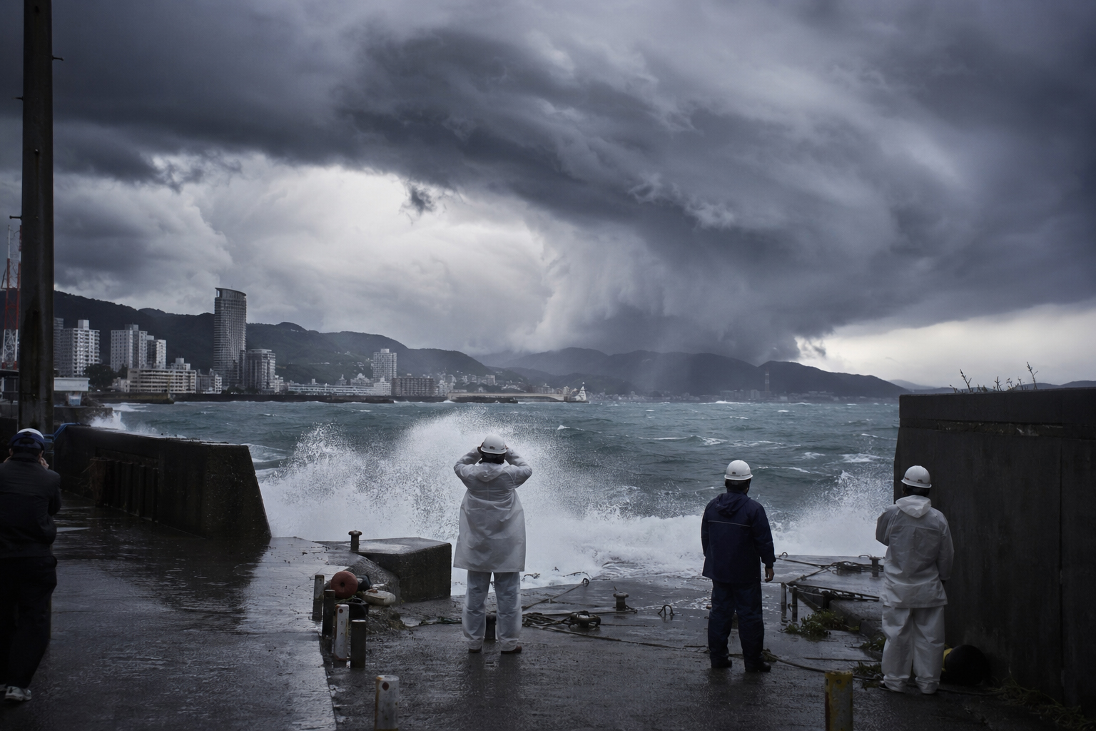
Mekkhala shows the risk is current
This is not an abstract seasonal warning. Reuters reported that as Typhoon Mekkhala neared the southern Ryukyu Islands, Japan ordered evacuations for more than 2 million people, issued flood and landslide warnings, suspended more than 200 flights, halted some trains and expressways, and saw Toyota pause production at a Kyushu factory. The Guardian also noted that Mekkhala could weaken near southern Japan while still increasing heavy-rain and coastal hazards.
Typhoons are not measured by maximum wind alone. A weakening tropical storm can still deliver destructive rainfall. In late June and July, that rainfall can combine with the rainy-season front and produce a wider disaster footprint than the storm’s center suggests.
Why the Nansei Islands prepare first
The Nansei Islands are Japan’s southern weather frontier: Okinawa, Miyako, Ishigaki, Iriomote, Amami, Tokunoshima and the surrounding islands. They are often the first Japanese communities affected by tropical systems forming over the western Pacific.
Island risk is different from mainland risk. Flights and ferries are lifelines. Supplies, medical transfers, tourism, ports, fisheries and agriculture all depend on weather windows. Once cancellations begin, choices narrow quickly. A “wait and see” approach that might work in a city can become risky on an island.
Japan’s typhoon memory
Japan has lived with typhoons for generations. The 1959 Isewan Typhoon reshaped modern disaster policy. Later storms — Typhoon Mireille in 1991, the extraordinary 2004 landfall season, Typhoon Jebi in 2018, Faxai and Hagibis in 2019, and Shanshan in 2024 — taught similar lessons in different regions. Wind can destroy buildings. Rain can change terrain. Seas can threaten ports. Transport stops. Power outages remake daily life.
Japan’s warning systems have improved dramatically: satellites, numerical models, AMeDAS observations, hazard maps, evacuation alerts, smartphone warnings, and more recent attention to linear rainbands. But more information does not automatically mean better decisions. People can become numb to alerts. Forecast cones can feel uncertain. Evacuation decisions can be delayed. The best way to read typhoon risk is not as a single event but as a multi-day sequence.
What travelers should understand
June and July are attractive travel months: Okinawa beaches, Amami nature, Kyushu hot springs, Kansai cities, Tokyo itineraries. But in a year with elevated early typhoon risk, travelers need more than hotel and flight reservations. They need backup days, cancellation awareness, travel insurance, ferry and airport alternatives, and a plan for getting back if a storm stalls.
This is especially important for islands. A typhoon can leave visitors unable to depart. Ferries stop, flights are canceled, and hotel stays must be extended. Even when skies look calm, distant typhoon swell can make beaches and reefs dangerous. When local residents stay out of the water, visitors should too.
What households should check now
| Item | Action |
|---|---|
| Power outages | Charge mobile batteries, prepare flashlights, radios and spare batteries. |
| Water and food | Keep at least several days of drinking water, shelf-stable food and special supplies for infants or older family members. |
| Outside the home | Secure or bring in potted plants, laundry poles, signs, bicycles and outdoor furniture. |
| Hazard maps | Check whether your home is in a landslide, flood or storm-surge risk zone. |
| Transport | Plan alternate routes and decide early when to return home from work, school or travel. |
Climate and the changing normal
No single seasonal forecast or storm proves climate change by itself. Typhoon numbers and tracks vary naturally from year to year. But warmer oceans can provide more moisture and energy, increasing the potential for heavy rainfall and rapid changes in storm behavior. In Japan, typhoon risk increasingly overlaps with hot seas, rainy-season fronts, linear rainbands and extreme heat.
The real question is not whether every year is abnormal. The question is whether earlier, wider and longer preparation is becoming part of the new normal.
Japan.co.jp view
Above-normal early typhoon risk is not a fear story. It is an action story. June in the Nansei Islands, July in western and eastern Japan, and the rainy-season front should be read as one connected seasonal risk.
Typhoons are part of Japan’s culture as well as its hazard map. Closing shutters, tying boats, protecting fields, opening shelters, suspending trains, canceling school — these are not overreactions. They are how lives are protected.
In 2026, June and July should not be treated as “before typhoon season.” Watch the forecasts. Follow local government alerts. Stay away from rivers and coasts during warnings. Prepare for power and logistics disruption. Leave slack in travel plans. Japan’s typhoon season is already here.
Sources and references
- Weathernews: 2026 Northwest Pacific typhoon season outlook, including above-normal June and July risk for Japan and elevated June risk near the Nansei Islands.
- Reuters: Typhoon Mekkhala prompted evacuations, flood and landslide warnings, flight suspensions, transport disruption and factory impact.
- The Guardian: Weather tracker on Mekkhala strengthening near the Philippines and potential heavy-rain impacts near southern Japan.
- Japan Meteorological Agency: Normal statistics for tropical cyclone formation, approach and landfall in the western North Pacific.
- Weathernews: Jangmi guidance highlighting flooding, landslide, storm surge and maritime risks in the Nansei Islands and mainland Japan.