Japan’s final weekend of June became the kind of weather story that cannot be explained by one storm track. Mekkhala came from the southwest, Higos approached from the east, and the seasonal rain front was already waiting over the archipelago. Together, they turned rain into a national operating problem: travel, factories, trains, highways, homes, tourists, and evacuation decisions all moved at once.
Why this is not a one-typhoon story
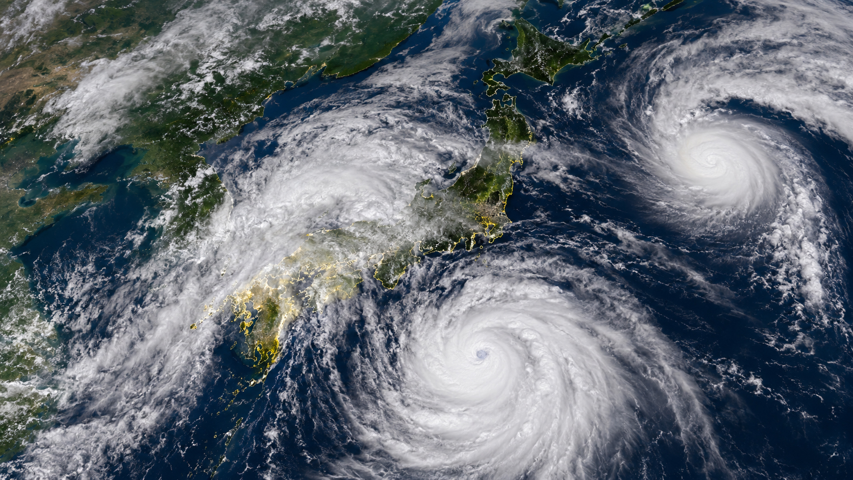
Japan knows how to watch a typhoon. But this setup is more complicated than a single eye on a map. Mekkhala, which had strengthened into a powerful typhoon earlier in the week, moved north near the Nansei Islands after its outer rain bands battered Taiwan. Higos then added a second tropical system near Japan. Most importantly, the rainy-season front was already draped across the country, ready to turn warm ocean moisture into long, organized bands of rain.
That is why the center line of a storm can be misleading. In Japan, the worst rain can fall far from a cyclone’s center. Moist air moves north, rises along the front, and builds cloud after cloud over the same region. The storm’s wind may dominate the television image, but in many Japanese disasters, water does the killing.
Damage was already beginning in western Japan
AP reported that heavy rain caused serious flooding across western Japan on Friday as Mekkhala and Higos approached. Alerts spread around Kyoto, Osaka and surrounding areas. In Nara, a man was injured after falling into a waterway, and more than 30 homes in Nara and Hiroshima were affected by flooding. This was not simply a warning about what might happen later. It was evidence that the ground and drainage systems were already under stress.
Reuters reported a wider picture: around one million people were advised to evacuate in some areas, more than 200 flights were cancelled, train services and expressways were disrupted, and Toyota briefly halted operations at its Kyushu plant. Weather had moved from the forecast page into the industrial page. In Japan, rain can stop a factory, a bullet train, an airport, and a family vacation in the same afternoon.
The hardest kind of weekend weather
This storm system arrived at the worst possible kind of time: a summer weekend. Late June sits between rainy season and school-holiday season. People travel for business, family, sports, tourism, and events. Airlines are not disrupted by wind alone; aircraft positioning, visibility, airport conditions, and connecting flights all matter. Railways can slow or stop when rain thresholds are reached, rivers rise, or slopes become unstable. Expressway closures push traffic onto local roads, where flooding and accidents become more likely.
For travelers, the uncertainty can be as stressful as the rain itself. Can I get there? Can I get home? Will the connection run? Is it safe to move with children or older relatives? Japanese weather coverage has to be more than a map. It has to be a decision guide.
The long history of front-plus-typhoon disasters
Japan’s most dangerous rain events often emerge from the combination of tropical systems and frontal boundaries. The 1959 Isewan Typhoon is remembered for storm surge and wind, but it also reshaped modern Japanese disaster policy. The disaster changed the way Japan thought about seawalls, evacuation, warnings, and national disaster response.
The 2018 western Japan floods showed how a stationary rainy-season front, fed by warm moist air, could devastate Okayama, Hiroshima, Ehime and other prefectures. A typhoon does not need to make a perfect direct hit to help create a disaster. When mountains, rivers, urban basins, saturated soil and long-duration rain line up, the result can be lethal. Later storms and floods, including Typhoon Hagibis in 2019 and the 2020 Kumamoto floods, reinforced the same lesson.
That is what makes Mekkhala and Higos more than a pair of numbered tropical systems. They are part of Japan’s recurring summer risk: typhoon moisture meeting the rainy-season front over a mountainous, densely built country. Climate change does not draw the track of one storm, but warmer oceans and a warmer atmosphere can increase the amount of moisture available to heavy-rain events. The background conditions are changing.
Why Kyushu and western Japan are exposed
Kyushu, Shikoku, Kinki, Tokai and the Pacific side of central Japan all share a vulnerability. Mountains are close to the sea. Rivers can be short and steep. Towns, roads and railways often sit in valleys, lowlands, coastal plains, or near slopes. The same geography that makes Japan beautiful can funnel water quickly when rain falls for hours.
Landslides are especially dangerous because they may occur after the heaviest rain has eased. Water enters the ground, weakens a slope, and then gravity finishes the work. That is why a lull in rain is not the same as safety. For people in hillside neighborhoods, near rivers, or in low-lying urban areas, the most important weather information may be local: a municipal alert, a river gauge, a landslide warning, a known underpass, a familiar slope behind the house.
A factory halt is a warning sign
Toyota Kyushu’s temporary production halt was one of the clearest signs that this was more than a local rain event. Japanese manufacturing depends on roads, ports, workers, component flows, inspection routines and precise timing. A plant can be physically safe, yet still stop because the surrounding network is unsafe or unreliable.
For an economy built on dependable logistics, weather is industrial policy. Automobiles, semiconductors, batteries, food, pharmaceuticals and tourism all assume that goods and people can move. Heavy rain challenges that assumption. Companies build business-continuity plans, municipalities update hazard maps, families check evacuation routes. None of that is abstract. It is how modern Japan stays open.
Taiwan was the early warning
Before Mekkhala’s rain bands affected Japan, they hit Taiwan. Reuters reported localized flooding around Taipei and southern Taiwan, rail disruptions, office and school closures, and evacuations near a possible barrier-lake breach. That matters for Japan because the western Pacific weather system is regional. The same storm environment can affect northern Philippines, Taiwan, the Nansei Islands, Kyushu and Honshu in sequence.
Japan’s relationship with Taiwan is not only diplomatic or economic. It is meteorological. Air routes, shipping lanes, semiconductor logistics, tourism flows and storm tracks connect the two islands. When Taiwan is hit by the outer bands of a northbound typhoon, Japan should pay attention.
Do not wait until evacuation feels obvious
Evacuation information often feels early. The sky may not look dangerous yet. The rain may still seem manageable. The river may look only a little higher than normal. But warnings are meant to preserve time. They are not only a statement that danger has arrived; they are a signal that movement may soon become harder, especially at night.
The correct action depends on the local risk. In cities, the problem may be flooded underpasses, underground shopping areas and parking structures. In mountain towns, it may be slope failure. Along rivers, it may be rising water. On islands and coastal roads, it may be isolation, rough seas and delayed ferries or flights. National weather maps are only the beginning. The real question is local: where is the river, where is the slope, where is the low road, and where can I go before it is dark?
| Situation | Practical decision point |
|---|---|
| Near a river | Use official water-level and municipal evacuation information. Do not go to look at the river. |
| Near slopes | Landslide risk can remain after rain weakens. |
| Urban areas | Watch underpasses, basements, parking garages and underground shopping areas. |
| Traveling | Check official railway and airline updates before leaving. |
| Nighttime | Consider moving before darkness if local officials advise it. |
Sunday may not mean finished
Weathernews said Mekkhala was expected to weaken, pass near the Nansei Islands and then move east along the southern coast of Honshu, with direct impacts possibly easing by the morning of June 28, depending on track and speed. That is not the same as an all-clear. Rivers may still be high. Ground may still be saturated. Roads and railways may need inspections. Airports may still be sorting aircraft and crews.
The second half of a weather disaster is often defined by fatigue. Evacuees are tired. Travelers want to get home. Businesses want to reopen. Operators want to restart trains, flights and production lines. But when everyone tries to resume at once, confusion can return. The rain may leave before the disruption does.
What Japan has learned
Japan is a disaster country, but it is also a preparedness country. The Japan Meteorological Agency, local governments, railway companies, airlines, manufacturers, schools and households all make layered decisions that keep society functioning. Still, the rain keeps finding weak points. Every year, “normal” becomes less reassuring.
The practical answers are simple and serious: check official alerts, charge phones, keep water and medicine ready, know the evacuation site, avoid rivers and slopes, and have a travel backup plan. The larger answer is cultural. To enjoy Japan in summer is also to respect Japan’s sky.
Mekkhala and Higos will disappear from the weather map. The lesson will remain. Japan’s summer is festivals, beaches, mountain trips, fireworks, baseball, soccer, cold noodles and the smell of rain on pavement. It is also flood season. Reading Japan means reading the clouds.
This weekend, the headline may be two storms. But the real story is the millions of decisions made beneath them.
Sources and references
この記事は、Reuters、AP、The Japan Times、Weathernews、気象庁の公開情報、および日本の過去の風水害に関する公的記録・報道を参考にしました。台風の進路、警報、運行情報、避難情報は短時間で変わるため、最新情報は気象庁、自治体、鉄道・航空各社の公式発表を確認してください。
- Reuters: Japan braces for double storms; evacuation, flights, trains, expressways and Toyota Kyushu impacts.
- AP: Heavy rain pounds western Japan as two tropical storms approach.
- The Japan Times: Heavy rain continues across Japan as Mekkhala and Higos approach.
- Weathernews: Typhoon Mekkhala forecast track near the Nansei Islands and southern Honshu.
- Japan Meteorological Agency: Tropical cyclone information.